You are here: Home > Network List > TA - USArray Transportable Network (new EarthScope stations) Stations List
> Station T24A Torres, Weston, CO, USA > Earthquake Result Viewer
T24A Torres, Weston, CO, USA - Earthquake Result Viewer

| Earthquake location: |
Tonga Islands |
| Earthquake latitude/longitude: |
-21.9/-173.8 |
| Earthquake time(UTC): |
2008/10/19 (293) 05:10:33 GMT |
| Earthquake Depth: |
29 km |
| Earthquake Magnitude: |
6.8 MB, 7.0 MS, 6.9 MW, 6.9 MW |
| Earthquake Catalog/Contributor: |
WHDF/NEIC |
|
| Network: |
TA USArray Transportable Network (new EarthScope stations) |
| Station: |
T24A Torres, Weston, CO, USA |
| Lat/Lon: |
37.07 N/105.05 W |
| Elevation: |
2510 m |
|
| Distance: |
87.3 deg |
| Az: |
48.273 deg |
| Baz: |
240.092 deg |
| Ray Param: |
0.04337715 |
| Estimated Moho Depth: |
35.25 km |
| Estimated Crust Vp/Vs: |
1.99 |
| Assumed Crust Vp: |
6.316 km/s |
| Estimated Crust Vs: |
3.182 km/s |
| Estimated Crust Poisson's Ratio: |
0.33 |
|
| Radial Match: |
95.61887 % |
| Radial Bump: |
261 |
| Transverse Match: |
70.758766 % |
| Transverse Bump: |
400 |
| SOD ConfigId: |
2556 |
| Insert Time: |
2010-03-06 02:30:13.034 +0000 |
| GWidth: |
2.5 |
| Max Bumps: |
400 |
| Tol: |
0.001 |
|
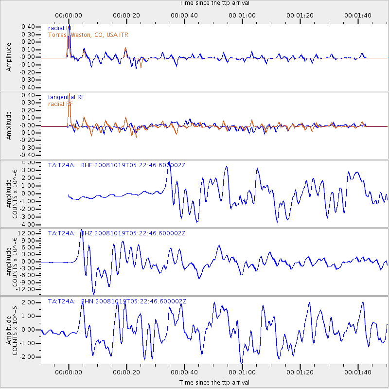
Signal To Noise
| Channel | StoN | STA | LTA |
| TA:T24A: :BHZ:20081019T05:22:46.600002Z | 31.071558 | 5.7048956E-6 | 1.8360508E-7 |
| TA:T24A: :BHN:20081019T05:22:46.600002Z | 3.2703125 | 7.0590755E-7 | 2.1585323E-7 |
| TA:T24A: :BHE:20081019T05:22:46.600002Z | 7.678708 | 1.6875084E-6 | 2.1976463E-7 |
| Arrivals |
| Ps | 5.6 SECOND |
| PpPs | 16 SECOND |
| PsPs/PpSs | 22 SECOND |


