You are here: Home > Network List > TA - USArray Transportable Network (new EarthScope stations) Stations List
> Station T24A Torres, Weston, CO, USA > Earthquake Result Viewer
T24A Torres, Weston, CO, USA - Earthquake Result Viewer
| Earthquake location: |
Vanuatu Islands |
| Earthquake latitude/longitude: |
-13.5/167.0 |
| Earthquake time(UTC): |
2008/09/08 (252) 18:52:06 GMT |
| Earthquake Depth: |
110 km |
| Earthquake Magnitude: |
6.4 MB, 6.9 MW, 6.9 MW |
| Earthquake Catalog/Contributor: |
WHDF/NEIC |
|
| Network: |
TA USArray Transportable Network (new EarthScope stations) |
| Station: |
T24A Torres, Weston, CO, USA |
| Lat/Lon: |
37.07 N/105.05 W |
| Elevation: |
2510 m |
|
| Distance: |
96.4 deg |
| Az: |
53.548 deg |
| Baz: |
258.029 deg |
| Ray Param: |
0.040431377 |
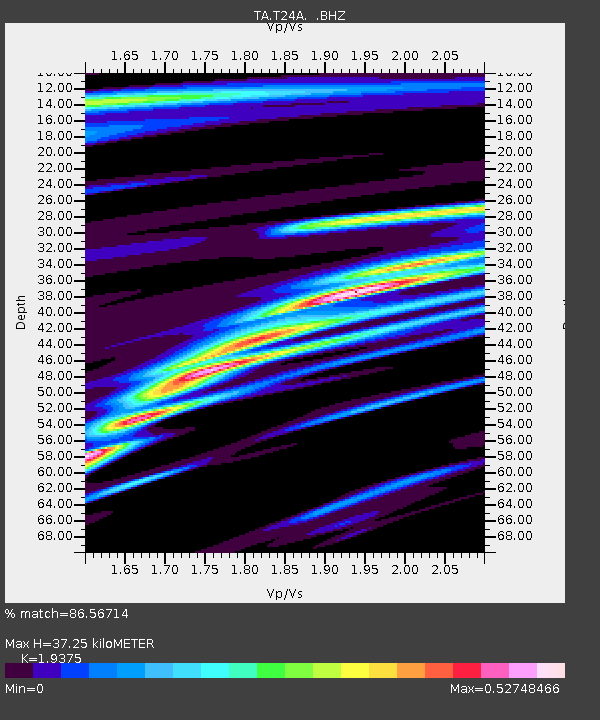
| Estimated Moho Depth: |
37.25 km |
| Estimated Crust Vp/Vs: |
1.94 |
| Assumed Crust Vp: |
6.316 km/s |
| Estimated Crust Vs: |
3.26 km/s |
| Estimated Crust Poisson's Ratio: |
0.32 |
|
| Radial Match: |
86.56714 % |
| Radial Bump: |
302 |
| Transverse Match: |
80.860214 % |
| Transverse Bump: |
396 |
| SOD ConfigId: |
2560 |
| Insert Time: |
2010-03-06 02:30:14.965 +0000 |
| GWidth: |
2.5 |
| Max Bumps: |
400 |
| Tol: |
0.001 |
|
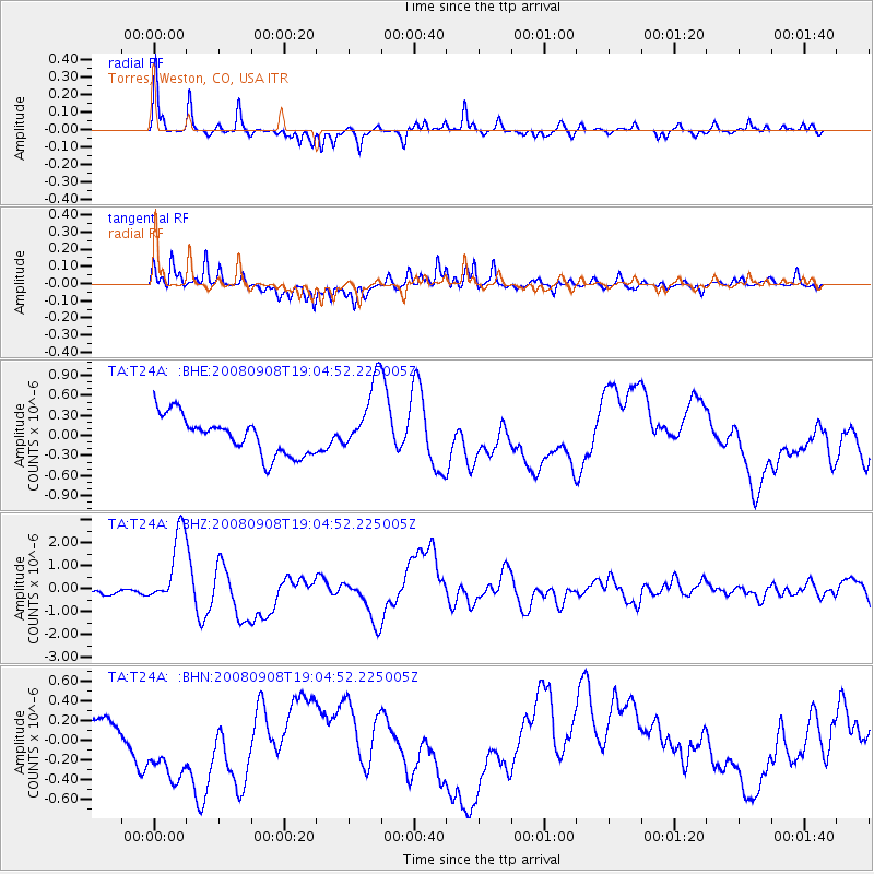
Signal To Noise
| Channel | StoN | STA | LTA |
| TA:T24A: :BHZ:20080908T19:04:52.225005Z | 17.690325 | 1.6279573E-6 | 9.2025296E-8 |
| TA:T24A: :BHN:20080908T19:04:52.225005Z | 2.802239 | 4.5064363E-7 | 1.6081556E-7 |
| TA:T24A: :BHE:20080908T19:04:52.225005Z | 1.9303408 | 5.5105954E-7 | 2.8547268E-7 |
| Arrivals |
| Ps | 5.6 SECOND |
| PpPs | 17 SECOND |
| PsPs/PpSs | 23 SECOND |


