You are here: Home > Network List > TA - USArray Transportable Network (new EarthScope stations) Stations List
> Station T24A Torres, Weston, CO, USA > Earthquake Result Viewer
T24A Torres, Weston, CO, USA - Earthquake Result Viewer
| Earthquake location: |
East Of Kuril Islands |
| Earthquake latitude/longitude: |
46.9/155.2 |
| Earthquake time(UTC): |
2009/01/15 (015) 17:49:39 GMT |
| Earthquake Depth: |
36 km |
| Earthquake Magnitude: |
6.9 MB, 7.5 MS, 7.4 MW, 7.4 MW |
| Earthquake Catalog/Contributor: |
WHDF/NEIC |
|
| Network: |
TA USArray Transportable Network (new EarthScope stations) |
| Station: |
T24A Torres, Weston, CO, USA |
| Lat/Lon: |
37.07 N/105.05 W |
| Elevation: |
2510 m |
|
| Distance: |
69.9 deg |
| Az: |
57.048 deg |
| Baz: |
313.945 deg |
| Ray Param: |
0.055264674 |
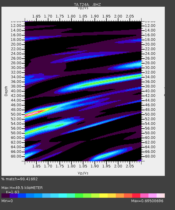
| Estimated Moho Depth: |
49.5 km |
| Estimated Crust Vp/Vs: |
1.63 |
| Assumed Crust Vp: |
6.316 km/s |
| Estimated Crust Vs: |
3.875 km/s |
| Estimated Crust Poisson's Ratio: |
0.20 |
|
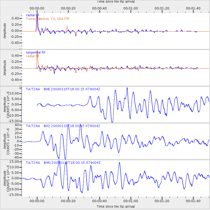
| Radial Match: |
98.41692 % |
| Radial Bump: |
244 |
| Transverse Match: |
95.08374 % |
| Transverse Bump: |
351 |
| SOD ConfigId: |
2834 |
| Insert Time: |
2010-03-06 02:30:24.335 +0000 |
| GWidth: |
2.5 |
| Max Bumps: |
400 |
| Tol: |
0.001 |
|
Signal To Noise
| Channel | StoN | STA | LTA |
| TA:T24A: :BHZ:20090115T18:00:15.674004Z | 21.0326 | 1.20777E-5 | 5.7423716E-7 |
| TA:T24A: :BHN:20090115T18:00:15.674004Z | 12.2038555 | 3.917871E-6 | 3.210355E-7 |
| TA:T24A: :BHE:20090115T18:00:15.674004Z | 5.711953 | 3.8238663E-6 | 6.694499E-7 |
| Arrivals |
| Ps | 5.1 SECOND |
| PpPs | 20 SECOND |
| PsPs/PpSs | 25 SECOND |


