You are here: Home > Network List > TA - USArray Transportable Network (new EarthScope stations) Stations List
> Station T24A Torres, Weston, CO, USA > Earthquake Result Viewer
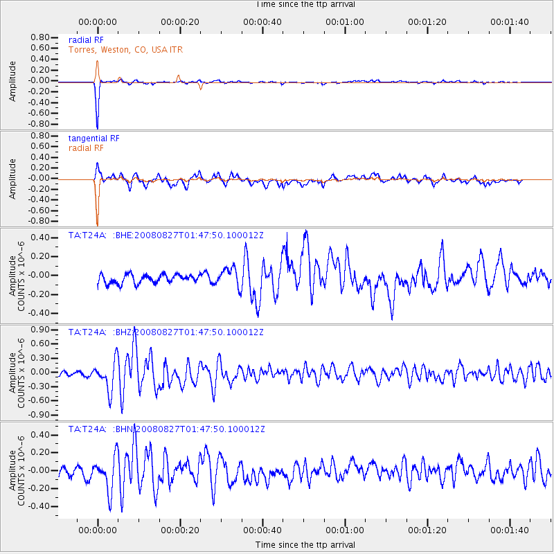
T24A Torres, Weston, CO, USA - Earthquake Result Viewer
*The percent match for this event was below the threshold and hence no stack was calculated.
| Earthquake location: |
Lake Baykal Region, Russia |
| Earthquake latitude/longitude: |
51.6/104.2 |
| Earthquake time(UTC): |
2008/08/27 (240) 01:35:32 GMT |
| Earthquake Depth: |
16 km |
| Earthquake Magnitude: |
5.8 MB, 6.2 MS, 6.2 MW, 6.2 MW |
| Earthquake Catalog/Contributor: |
WHDF/NEIC |
|
| Network: |
TA USArray Transportable Network (new EarthScope stations) |
| Station: |
T24A Torres, Weston, CO, USA |
| Lat/Lon: |
37.07 N/105.05 W |
| Elevation: |
2510 m |
|
| Distance: |
88.1 deg |
| Az: |
22.988 deg |
| Baz: |
342.272 deg |
| Ray Param: |
$rayparam |
*The percent match for this event was below the threshold and hence was not used in the summary stack. |
|
| Radial Match: |
97.65487 % |
| Radial Bump: |
141 |
| Transverse Match: |
71.33145 % |
| Transverse Bump: |
399 |
| SOD ConfigId: |
2504 |
| Insert Time: |
2010-03-06 02:30:42.423 +0000 |
| GWidth: |
2.5 |
| Max Bumps: |
400 |
| Tol: |
0.001 |
|
Signal To Noise
| Channel | StoN | STA | LTA |
| TA:T24A: :BHZ:20080827T01:47:50.100012Z | 4.5177526 | 3.2847953E-7 | 7.270861E-8 |
| TA:T24A: :BHN:20080827T01:47:50.100012Z | 4.0843883 | 1.9777622E-7 | 4.8422482E-8 |
| TA:T24A: :BHE:20080827T01:47:50.100012Z | 2.2116756 | 1.0201888E-7 | 4.612741E-8 |
| Arrivals |
| Ps | |
| PpPs | |
| PsPs/PpSs | |


