You are here: Home > Network List > TA - USArray Transportable Network (new EarthScope stations) Stations List
> Station T24A Torres, Weston, CO, USA > Earthquake Result Viewer
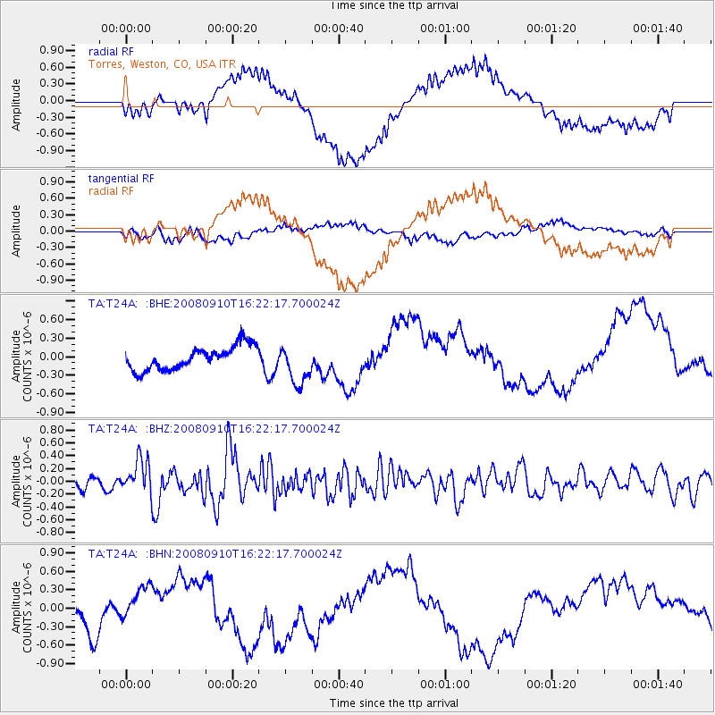
T24A Torres, Weston, CO, USA - Earthquake Result Viewer
*The percent match for this event was below the threshold and hence no stack was calculated.
| Earthquake location: |
Northern Chile |
| Earthquake latitude/longitude: |
-20.3/-69.2 |
| Earthquake time(UTC): |
2008/09/10 (254) 16:12:04 GMT |
| Earthquake Depth: |
38 km |
| Earthquake Magnitude: |
5.6 MB, 5.3 MS |
| Earthquake Catalog/Contributor: |
WHDF/NEIC |
|
| Network: |
TA USArray Transportable Network (new EarthScope stations) |
| Station: |
T24A Torres, Weston, CO, USA |
| Lat/Lon: |
37.07 N/105.05 W |
| Elevation: |
2510 m |
|
| Distance: |
66.3 deg |
| Az: |
329.247 deg |
| Baz: |
143.112 deg |
| Ray Param: |
$rayparam |
*The percent match for this event was below the threshold and hence was not used in the summary stack. |
|
| Radial Match: |
59.743168 % |
| Radial Bump: |
400 |
| Transverse Match: |
58.274612 % |
| Transverse Bump: |
400 |
| SOD ConfigId: |
2560 |
| Insert Time: |
2010-03-06 02:30:48.388 +0000 |
| GWidth: |
2.5 |
| Max Bumps: |
400 |
| Tol: |
0.001 |
|
Signal To Noise
| Channel | StoN | STA | LTA |
| TA:T24A: :BHZ:20080910T16:22:17.700024Z | 2.753366 | 2.6689116E-7 | 9.693269E-8 |
| TA:T24A: :BHN:20080910T16:22:17.700024Z | 0.60144407 | 2.3672585E-7 | 3.9359577E-7 |
| TA:T24A: :BHE:20080910T16:22:17.700024Z | 1.7319225 | 3.268429E-7 | 1.8871681E-7 |
| Arrivals |
| Ps | |
| PpPs | |
| PsPs/PpSs | |


