You are here: Home > Network List > N4 - Central and EAstern US Network Stations List
> Station T45B Paducah, KY, USA > Earthquake Result Viewer
T45B Paducah, KY, USA - Earthquake Result Viewer
| Earthquake location: |
La Rioja Province, Argentina |
| Earthquake latitude/longitude: |
-28.6/-68.7 |
| Earthquake time(UTC): |
2017/08/01 (213) 06:13:53 GMT |
| Earthquake Depth: |
85 km |
| Earthquake Magnitude: |
5.6 Mww |
| Earthquake Catalog/Contributor: |
NEIC PDE/us |
|
| Network: |
N4 Central and EAstern US Network |
| Station: |
T45B Paducah, KY, USA |
| Lat/Lon: |
37.02 N/88.65 W |
| Elevation: |
136 m |
|
| Distance: |
67.9 deg |
| Az: |
342.861 deg |
| Baz: |
161.102 deg |
| Ray Param: |
0.056471597 |
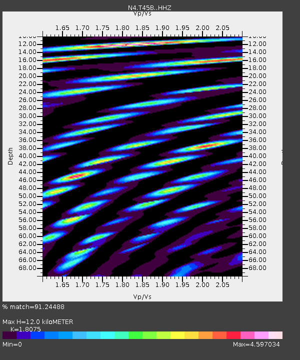
| Estimated Moho Depth: |
12.0 km |
| Estimated Crust Vp/Vs: |
1.81 |
| Assumed Crust Vp: |
6.444 km/s |
| Estimated Crust Vs: |
3.565 km/s |
| Estimated Crust Poisson's Ratio: |
0.28 |
|
| Radial Match: |
91.24488 % |
| Radial Bump: |
400 |
| Transverse Match: |
79.77304 % |
| Transverse Bump: |
400 |
| SOD ConfigId: |
13570011 |
| Insert Time: |
2019-04-28 12:37:59.078 +0000 |
| GWidth: |
2.5 |
| Max Bumps: |
400 |
| Tol: |
0.001 |
|

Signal To Noise
| Channel | StoN | STA | LTA |
| N4:T45B: :HHZ:20170801T06:24:12.339983Z | 10.24877 | 1.4976724E-6 | 1.4613191E-7 |
| N4:T45B: :HHN:20170801T06:24:12.339983Z | 15.672962 | 2.9860512E-6 | 1.9052246E-7 |
| N4:T45B: :HHE:20170801T06:24:12.339983Z | 5.025344 | 9.3481685E-7 | 1.8602047E-7 |
| Arrivals |
| Ps | 1.6 SECOND |
| PpPs | 5.0 SECOND |
| PsPs/PpSs | 6.6 SECOND |


