You are here: Home > Network List > IU - Global Seismograph Network (GSN - IRIS/USGS) Stations List
> Station RSSD Black Hills, South Dakota, USA > Earthquake Result Viewer
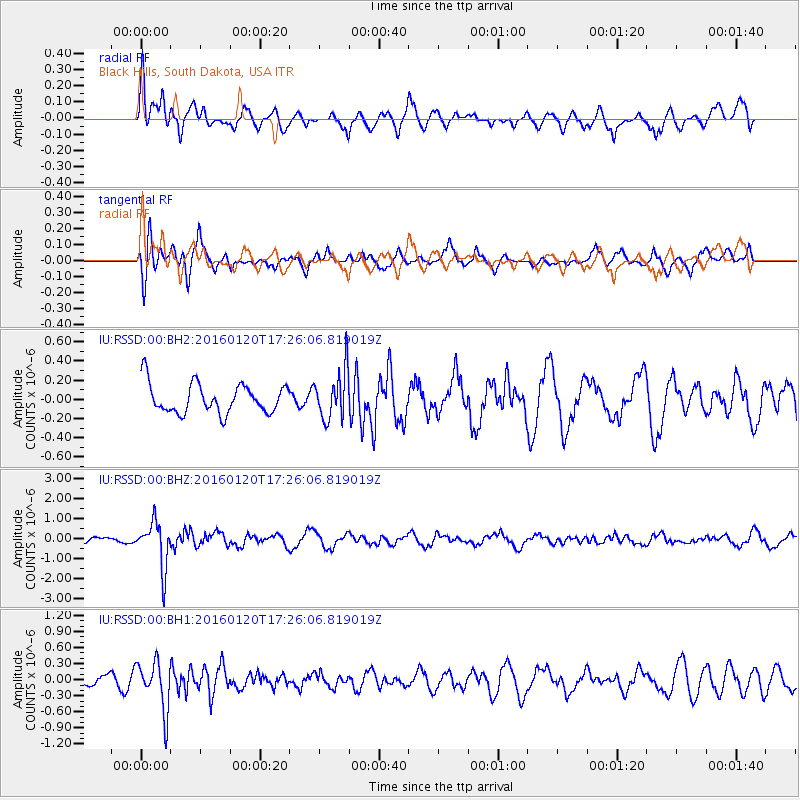
RSSD Black Hills, South Dakota, USA - Earthquake Result Viewer
*The percent match for this event was below the threshold and hence no stack was calculated.
| Earthquake location: |
Qinghai, China |
| Earthquake latitude/longitude: |
37.7/101.6 |
| Earthquake time(UTC): |
2016/01/20 (020) 17:13:14 GMT |
| Earthquake Depth: |
10 km |
| Earthquake Magnitude: |
5.9 MWB |
| Earthquake Catalog/Contributor: |
NEIC PDE/NEIC COMCAT |
|
| Network: |
IU Global Seismograph Network (GSN - IRIS/USGS) |
| Station: |
RSSD Black Hills, South Dakota, USA |
| Lat/Lon: |
44.12 N/104.04 W |
| Elevation: |
2090 m |
|
| Distance: |
95.3 deg |
| Az: |
18.225 deg |
| Baz: |
339.857 deg |
| Ray Param: |
$rayparam |
*The percent match for this event was below the threshold and hence was not used in the summary stack. |
|
| Radial Match: |
62.585693 % |
| Radial Bump: |
400 |
| Transverse Match: |
69.48284 % |
| Transverse Bump: |
395 |
| SOD ConfigId: |
1399611 |
| Insert Time: |
2016-02-03 17:28:29.970 +0000 |
| GWidth: |
2.5 |
| Max Bumps: |
400 |
| Tol: |
0.001 |
|
Signal To Noise
| Channel | StoN | STA | LTA |
| IU:RSSD:00:BHZ:20160120T17:26:06.819019Z | 4.6770167 | 1.1545028E-6 | 2.4684596E-7 |
| IU:RSSD:00:BH1:20160120T17:26:06.819019Z | 2.001764 | 4.5668384E-7 | 2.2814068E-7 |
| IU:RSSD:00:BH2:20160120T17:26:06.819019Z | 1.6560309 | 2.556776E-7 | 1.543918E-7 |
| Arrivals |
| Ps | |
| PpPs | |
| PsPs/PpSs | |


