You are here: Home > Network List > TA - USArray Transportable Network (new EarthScope stations) Stations List
> Station T24A Torres, Weston, CO, USA > Earthquake Result Viewer
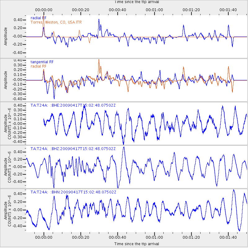
T24A Torres, Weston, CO, USA - Earthquake Result Viewer
*The percent match for this event was below the threshold and hence no stack was calculated.
| Earthquake location: |
Kuril Islands |
| Earthquake latitude/longitude: |
46.2/151.7 |
| Earthquake time(UTC): |
2009/04/17 (107) 14:51:58 GMT |
| Earthquake Depth: |
49 km |
| Earthquake Magnitude: |
5.5 MB, 5.0 MS, 5.7 MW, 5.6 MW |
| Earthquake Catalog/Contributor: |
WHDF/NEIC |
|
| Network: |
TA USArray Transportable Network (new EarthScope stations) |
| Station: |
T24A Torres, Weston, CO, USA |
| Lat/Lon: |
37.07 N/105.05 W |
| Elevation: |
2510 m |
|
| Distance: |
72.3 deg |
| Az: |
54.814 deg |
| Baz: |
314.753 deg |
| Ray Param: |
$rayparam |
*The percent match for this event was below the threshold and hence was not used in the summary stack. |
|
| Radial Match: |
52.091103 % |
| Radial Bump: |
400 |
| Transverse Match: |
47.47552 % |
| Transverse Bump: |
400 |
| SOD ConfigId: |
2658 |
| Insert Time: |
2010-03-06 02:31:10.494 +0000 |
| GWidth: |
2.5 |
| Max Bumps: |
400 |
| Tol: |
0.001 |
|
Signal To Noise
| Channel | StoN | STA | LTA |
| TA:T24A: :BHZ:20090417T15:02:48.07502Z | 0.6350708 | 1.7002155E-7 | 2.677206E-7 |
| TA:T24A: :BHN:20090417T15:02:48.07502Z | 1.7816329 | 4.0500117E-7 | 2.2732021E-7 |
| TA:T24A: :BHE:20090417T15:02:48.07502Z | 1.0312246 | 1.7845427E-7 | 1.7305082E-7 |
| Arrivals |
| Ps | |
| PpPs | |
| PsPs/PpSs | |


