You are here: Home > Network List > TA - USArray Transportable Network (new EarthScope stations) Stations List
> Station T24A Torres, Weston, CO, USA > Earthquake Result Viewer
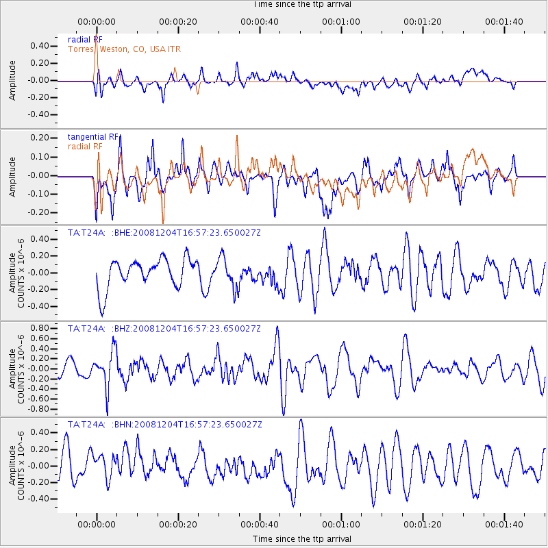
T24A Torres, Weston, CO, USA - Earthquake Result Viewer
*The percent match for this event was below the threshold and hence no stack was calculated.
| Earthquake location: |
Chile-Bolivia Border Region |
| Earthquake latitude/longitude: |
-21.4/-68.3 |
| Earthquake time(UTC): |
2008/12/04 (339) 16:47:09 GMT |
| Earthquake Depth: |
115 km |
| Earthquake Magnitude: |
5.5 MB, 5.5 MW, 5.5 MW |
| Earthquake Catalog/Contributor: |
WHDF/NEIC |
|
| Network: |
TA USArray Transportable Network (new EarthScope stations) |
| Station: |
T24A Torres, Weston, CO, USA |
| Lat/Lon: |
37.07 N/105.05 W |
| Elevation: |
2510 m |
|
| Distance: |
67.7 deg |
| Az: |
328.842 deg |
| Baz: |
142.923 deg |
| Ray Param: |
$rayparam |
*The percent match for this event was below the threshold and hence was not used in the summary stack. |
|
| Radial Match: |
43.839222 % |
| Radial Bump: |
400 |
| Transverse Match: |
59.567844 % |
| Transverse Bump: |
400 |
| SOD ConfigId: |
2658 |
| Insert Time: |
2010-03-06 02:31:14.101 +0000 |
| GWidth: |
2.5 |
| Max Bumps: |
400 |
| Tol: |
0.001 |
|
Signal To Noise
| Channel | StoN | STA | LTA |
| TA:T24A: :BHZ:20081204T16:57:23.650027Z | 1.9570422 | 3.6420602E-7 | 1.8610024E-7 |
| TA:T24A: :BHN:20081204T16:57:23.650027Z | 0.97501266 | 1.7394979E-7 | 1.7840772E-7 |
| TA:T24A: :BHE:20081204T16:57:23.650027Z | 1.0556558 | 1.8214942E-7 | 1.7254621E-7 |
| Arrivals |
| Ps | |
| PpPs | |
| PsPs/PpSs | |


