You are here: Home > Network List > TA - USArray Transportable Network (new EarthScope stations) Stations List
> Station T24A Torres, Weston, CO, USA > Earthquake Result Viewer
T24A Torres, Weston, CO, USA - Earthquake Result Viewer
*The percent match for this event was below the threshold and hence no stack was calculated.
| Earthquake location: |
Northern Mid-Atlantic Ridge |
| Earthquake latitude/longitude: |
47.0/-27.3 |
| Earthquake time(UTC): |
2008/12/19 (354) 08:31:51 GMT |
| Earthquake Depth: |
2.0 km |
| Earthquake Magnitude: |
5.8 MB, 5.6 MS, 5.9 MW, 5.8 MW |
| Earthquake Catalog/Contributor: |
WHDF/NEIC |
|
| Network: |
TA USArray Transportable Network (new EarthScope stations) |
| Station: |
T24A Torres, Weston, CO, USA |
| Lat/Lon: |
37.07 N/105.05 W |
| Elevation: |
2510 m |
|
| Distance: |
56.4 deg |
| Az: |
290.178 deg |
| Baz: |
53.44 deg |
| Ray Param: |
$rayparam |
*The percent match for this event was below the threshold and hence was not used in the summary stack. |
|
| Radial Match: |
75.13221 % |
| Radial Bump: |
400 |
| Transverse Match: |
34.433506 % |
| Transverse Bump: |
400 |
| SOD ConfigId: |
2658 |
| Insert Time: |
2010-03-06 02:31:27.069 +0000 |
| GWidth: |
2.5 |
| Max Bumps: |
400 |
| Tol: |
0.001 |
|
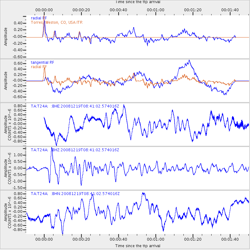
Signal To Noise
| Channel | StoN | STA | LTA |
| TA:T24A: :BHZ:20081219T08:41:02.574016Z | 6.707745 | 6.626274E-7 | 9.8785414E-8 |
| TA:T24A: :BHN:20081219T08:41:02.574016Z | 1.4740365 | 5.709437E-7 | 3.873335E-7 |
| TA:T24A: :BHE:20081219T08:41:02.574016Z | 1.1051738 | 3.9579447E-7 | 3.581287E-7 |
| Arrivals |
| Ps | |
| PpPs | |
| PsPs/PpSs | |


