You are here: Home > Network List > TA - USArray Transportable Network (new EarthScope stations) Stations List
> Station T24A Torres, Weston, CO, USA > Earthquake Result Viewer
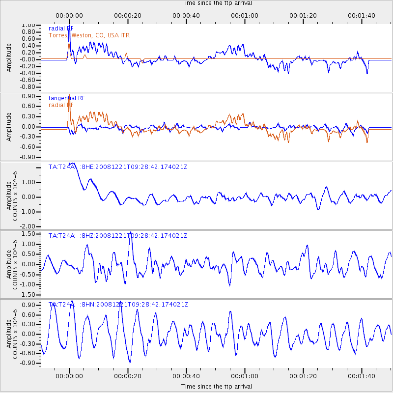
T24A Torres, Weston, CO, USA - Earthquake Result Viewer
*The percent match for this event was below the threshold and hence no stack was calculated.
| Earthquake location: |
Off East Coast Of Honshu, Japan |
| Earthquake latitude/longitude: |
36.5/142.3 |
| Earthquake time(UTC): |
2008/12/21 (356) 09:16:44 GMT |
| Earthquake Depth: |
13 km |
| Earthquake Magnitude: |
5.6 MB, 5.7 MS, 5.9 MW, 5.9 MW |
| Earthquake Catalog/Contributor: |
WHDF/NEIC |
|
| Network: |
TA USArray Transportable Network (new EarthScope stations) |
| Station: |
T24A Torres, Weston, CO, USA |
| Lat/Lon: |
37.07 N/105.05 W |
| Elevation: |
2510 m |
|
| Distance: |
83.8 deg |
| Az: |
47.95 deg |
| Baz: |
311.608 deg |
| Ray Param: |
$rayparam |
*The percent match for this event was below the threshold and hence was not used in the summary stack. |
|
| Radial Match: |
35.463177 % |
| Radial Bump: |
400 |
| Transverse Match: |
50.988194 % |
| Transverse Bump: |
346 |
| SOD ConfigId: |
2658 |
| Insert Time: |
2010-03-06 02:31:28.745 +0000 |
| GWidth: |
2.5 |
| Max Bumps: |
400 |
| Tol: |
0.001 |
|
Signal To Noise
| Channel | StoN | STA | LTA |
| TA:T24A: :BHZ:20081221T09:28:42.174021Z | 0.8089499 | 2.09026E-7 | 2.5839176E-7 |
| TA:T24A: :BHN:20081221T09:28:42.174021Z | 0.9668632 | 8.4863547E-7 | 8.777203E-7 |
| TA:T24A: :BHE:20081221T09:28:42.174021Z | 0.9403795 | 7.559096E-7 | 8.038346E-7 |
| Arrivals |
| Ps | |
| PpPs | |
| PsPs/PpSs | |


