You are here: Home > Network List > TA - USArray Transportable Network (new EarthScope stations) Stations List
> Station T24A Torres, Weston, CO, USA > Earthquake Result Viewer
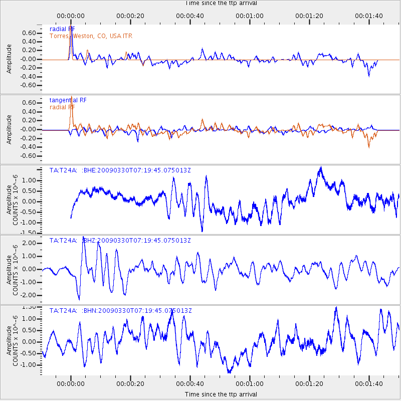
T24A Torres, Weston, CO, USA - Earthquake Result Viewer
*The percent match for this event was below the threshold and hence no stack was calculated.
| Earthquake location: |
Kodiak Island Region, Alaska |
| Earthquake latitude/longitude: |
56.5/-152.7 |
| Earthquake time(UTC): |
2009/03/30 (089) 07:13:07 GMT |
| Earthquake Depth: |
21 km |
| Earthquake Magnitude: |
5.9 MB, 5.9 MS, 5.9 MW, 5.9 MW |
| Earthquake Catalog/Contributor: |
WHDF/NEIC |
|
| Network: |
TA USArray Transportable Network (new EarthScope stations) |
| Station: |
T24A Torres, Weston, CO, USA |
| Lat/Lon: |
37.07 N/105.05 W |
| Elevation: |
2510 m |
|
| Distance: |
37.1 deg |
| Az: |
101.078 deg |
| Baz: |
317.189 deg |
| Ray Param: |
$rayparam |
*The percent match for this event was below the threshold and hence was not used in the summary stack. |
|
| Radial Match: |
38.312656 % |
| Radial Bump: |
400 |
| Transverse Match: |
68.00626 % |
| Transverse Bump: |
400 |
| SOD ConfigId: |
2658 |
| Insert Time: |
2010-03-06 02:31:29.673 +0000 |
| GWidth: |
2.5 |
| Max Bumps: |
400 |
| Tol: |
0.001 |
|
Signal To Noise
| Channel | StoN | STA | LTA |
| TA:T24A: :BHZ:20090330T07:19:45.075013Z | 5.9662013 | 1.2744823E-6 | 2.1361704E-7 |
| TA:T24A: :BHN:20090330T07:19:45.075013Z | 1.1320137 | 4.992637E-7 | 4.4104033E-7 |
| TA:T24A: :BHE:20090330T07:19:45.075013Z | 1.8061651 | 4.944553E-7 | 2.7375975E-7 |
| Arrivals |
| Ps | |
| PpPs | |
| PsPs/PpSs | |


