You are here: Home > Network List > TA - USArray Transportable Network (new EarthScope stations) Stations List
> Station T24A Torres, Weston, CO, USA > Earthquake Result Viewer
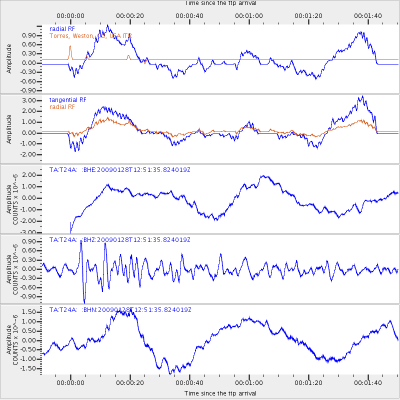
T24A Torres, Weston, CO, USA - Earthquake Result Viewer
*The percent match for this event was below the threshold and hence no stack was calculated.
| Earthquake location: |
Samoa Islands Region |
| Earthquake latitude/longitude: |
-17.0/-172.1 |
| Earthquake time(UTC): |
2009/01/28 (028) 12:39:42 GMT |
| Earthquake Depth: |
10 km |
| Earthquake Magnitude: |
5.6 MB, 5.3 MS, 5.5 MW |
| Earthquake Catalog/Contributor: |
WHDF/NEIC |
|
| Network: |
TA USArray Transportable Network (new EarthScope stations) |
| Station: |
T24A Torres, Weston, CO, USA |
| Lat/Lon: |
37.07 N/105.05 W |
| Elevation: |
2510 m |
|
| Distance: |
82.8 deg |
| Az: |
47.911 deg |
| Baz: |
242.616 deg |
| Ray Param: |
$rayparam |
*The percent match for this event was below the threshold and hence was not used in the summary stack. |
|
| Radial Match: |
42.570545 % |
| Radial Bump: |
400 |
| Transverse Match: |
37.992413 % |
| Transverse Bump: |
400 |
| SOD ConfigId: |
2658 |
| Insert Time: |
2010-03-06 02:31:36.351 +0000 |
| GWidth: |
2.5 |
| Max Bumps: |
400 |
| Tol: |
0.001 |
|
Signal To Noise
| Channel | StoN | STA | LTA |
| TA:T24A: :BHZ:20090128T12:51:35.824019Z | 5.2804093 | 4.529315E-7 | 8.577584E-8 |
| TA:T24A: :BHN:20090128T12:51:35.824019Z | 0.21343504 | 2.1960236E-7 | 1.0288956E-6 |
| TA:T24A: :BHE:20090128T12:51:35.824019Z | 0.46164444 | 4.5818757E-7 | 9.925118E-7 |
| Arrivals |
| Ps | |
| PpPs | |
| PsPs/PpSs | |


