You are here: Home > Network List > UW - Pacific Northwest Regional Seismic Network Stations List
> Station LEBA Lebam, WA, USA > Earthquake Result Viewer
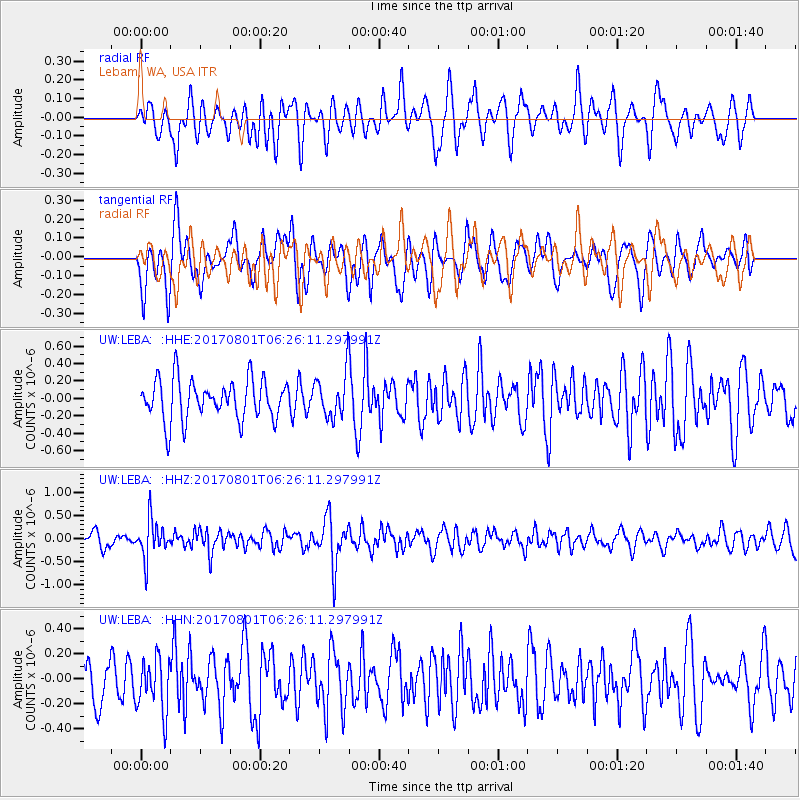
LEBA Lebam, WA, USA - Earthquake Result Viewer
*The percent match for this event was below the threshold and hence no stack was calculated.
| Earthquake location: |
La Rioja Province, Argentina |
| Earthquake latitude/longitude: |
-28.6/-68.7 |
| Earthquake time(UTC): |
2017/08/01 (213) 06:13:53 GMT |
| Earthquake Depth: |
85 km |
| Earthquake Magnitude: |
5.6 Mww |
| Earthquake Catalog/Contributor: |
NEIC PDE/us |
|
| Network: |
UW Pacific Northwest Regional Seismic Network |
| Station: |
LEBA Lebam, WA, USA |
| Lat/Lon: |
46.55 N/123.56 W |
| Elevation: |
73 m |
|
| Distance: |
89.7 deg |
| Az: |
325.639 deg |
| Baz: |
133.998 deg |
| Ray Param: |
$rayparam |
*The percent match for this event was below the threshold and hence was not used in the summary stack. |
|
| Radial Match: |
51.08102 % |
| Radial Bump: |
400 |
| Transverse Match: |
45.96484 % |
| Transverse Bump: |
400 |
| SOD ConfigId: |
13570011 |
| Insert Time: |
2019-04-28 12:42:07.439 +0000 |
| GWidth: |
2.5 |
| Max Bumps: |
400 |
| Tol: |
0.001 |
|
Signal To Noise
| Channel | StoN | STA | LTA |
| UW:LEBA: :HHZ:20170801T06:26:11.297991Z | 2.2044811 | 4.0426966E-7 | 1.8338541E-7 |
| UW:LEBA: :HHN:20170801T06:26:11.297991Z | 1.0614256 | 2.1334567E-7 | 2.0099918E-7 |
| UW:LEBA: :HHE:20170801T06:26:11.297991Z | 1.0927083 | 2.5204807E-7 | 2.3066363E-7 |
| Arrivals |
| Ps | |
| PpPs | |
| PsPs/PpSs | |


