You are here: Home > Network List > TA - USArray Transportable Network (new EarthScope stations) Stations List
> Station T24A Torres, Weston, CO, USA > Earthquake Result Viewer
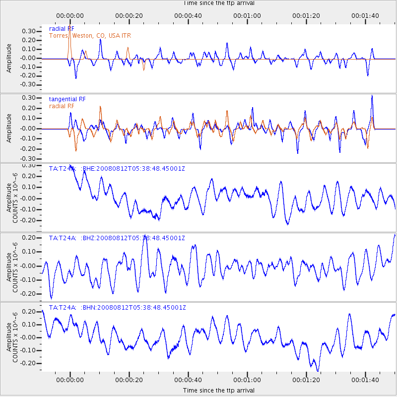
T24A Torres, Weston, CO, USA - Earthquake Result Viewer
*The percent match for this event was below the threshold and hence no stack was calculated.
| Earthquake location: |
Santa Cruz Islands |
| Earthquake latitude/longitude: |
-11.4/166.2 |
| Earthquake time(UTC): |
2008/08/12 (225) 05:25:57 GMT |
| Earthquake Depth: |
38 km |
| Earthquake Magnitude: |
5.9 MW, 5.4 MS, 5.2 MB, 5.8 MW |
| Earthquake Catalog/Contributor: |
WHDF/NEIC |
|
| Network: |
TA USArray Transportable Network (new EarthScope stations) |
| Station: |
T24A Torres, Weston, CO, USA |
| Lat/Lon: |
37.07 N/105.05 W |
| Elevation: |
2510 m |
|
| Distance: |
95.8 deg |
| Az: |
53.483 deg |
| Baz: |
260.122 deg |
| Ray Param: |
$rayparam |
*The percent match for this event was below the threshold and hence was not used in the summary stack. |
|
| Radial Match: |
21.066507 % |
| Radial Bump: |
306 |
| Transverse Match: |
22.466019 % |
| Transverse Bump: |
253 |
| SOD ConfigId: |
2658 |
| Insert Time: |
2010-03-06 02:31:38.747 +0000 |
| GWidth: |
2.5 |
| Max Bumps: |
400 |
| Tol: |
0.001 |
|
Signal To Noise
| Channel | StoN | STA | LTA |
| TA:T24A: :BHZ:20080812T05:38:48.45001Z | 0.7798929 | 2.204119E-7 | 2.8261815E-7 |
| TA:T24A: :BHN:20080812T05:38:48.45001Z | 1.0156657 | 2.1578059E-7 | 2.1245238E-7 |
| TA:T24A: :BHE:20080812T05:38:48.45001Z | 1.1925173 | 1.4114222E-7 | 1.1835653E-7 |
| Arrivals |
| Ps | |
| PpPs | |
| PsPs/PpSs | |


