You are here: Home > Network List > TA - USArray Transportable Network (new EarthScope stations) Stations List
> Station T24A Torres, Weston, CO, USA > Earthquake Result Viewer
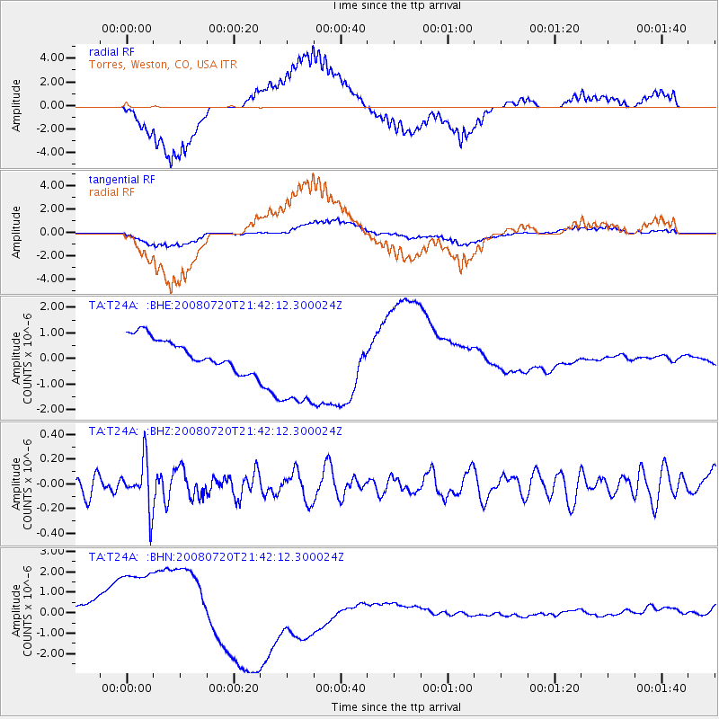
T24A Torres, Weston, CO, USA - Earthquake Result Viewer
*The percent match for this event was below the threshold and hence no stack was calculated.
| Earthquake location: |
Bonin Islands, Japan Region |
| Earthquake latitude/longitude: |
27.8/139.6 |
| Earthquake time(UTC): |
2008/07/20 (202) 21:30:29 GMT |
| Earthquake Depth: |
481 km |
| Earthquake Magnitude: |
5.8 MW, 5.1 MB, 5.8 MW |
| Earthquake Catalog/Contributor: |
WHDF/NEIC |
|
| Network: |
TA USArray Transportable Network (new EarthScope stations) |
| Station: |
T24A Torres, Weston, CO, USA |
| Lat/Lon: |
37.07 N/105.05 W |
| Elevation: |
2510 m |
|
| Distance: |
91.4 deg |
| Az: |
46.312 deg |
| Baz: |
306.762 deg |
| Ray Param: |
$rayparam |
*The percent match for this event was below the threshold and hence was not used in the summary stack. |
|
| Radial Match: |
34.6734 % |
| Radial Bump: |
400 |
| Transverse Match: |
40.945377 % |
| Transverse Bump: |
400 |
| SOD ConfigId: |
2504 |
| Insert Time: |
2010-03-06 02:31:42.262 +0000 |
| GWidth: |
2.5 |
| Max Bumps: |
400 |
| Tol: |
0.001 |
|
Signal To Noise
| Channel | StoN | STA | LTA |
| TA:T24A: :BHZ:20080720T21:42:12.300024Z | 2.175822 | 1.9381899E-7 | 8.907852E-8 |
| TA:T24A: :BHN:20080720T21:42:12.300024Z | 3.0779335 | 2.2657193E-6 | 7.3611704E-7 |
| TA:T24A: :BHE:20080720T21:42:12.300024Z | 3.0053318 | 1.8392593E-6 | 6.1199876E-7 |
| Arrivals |
| Ps | |
| PpPs | |
| PsPs/PpSs | |


