You are here: Home > Network List > TA - USArray Transportable Network (new EarthScope stations) Stations List
> Station I28A Midland, SD, USA > Earthquake Result Viewer
I28A Midland, SD, USA - Earthquake Result Viewer
| Earthquake location: |
Crete, Greece |
| Earthquake latitude/longitude: |
34.2/25.5 |
| Earthquake time(UTC): |
2009/07/01 (182) 09:30:10 GMT |
| Earthquake Depth: |
19 km |
| Earthquake Magnitude: |
6.1 MB, 6.3 MS, 6.4 MW, 6.4 MW |
| Earthquake Catalog/Contributor: |
WHDF/NEIC |
|
| Network: |
TA USArray Transportable Network (new EarthScope stations) |
| Station: |
I28A Midland, SD, USA |
| Lat/Lon: |
44.00 N/101.17 W |
| Elevation: |
655 m |
|
| Distance: |
88.3 deg |
| Az: |
324.597 deg |
| Baz: |
41.731 deg |
| Ray Param: |
0.04268078 |
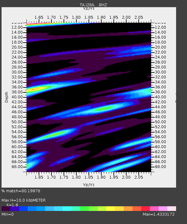
| Estimated Moho Depth: |
10.0 km |
| Estimated Crust Vp/Vs: |
1.60 |
| Assumed Crust Vp: |
6.483 km/s |
| Estimated Crust Vs: |
4.052 km/s |
| Estimated Crust Poisson's Ratio: |
0.18 |
|
| Radial Match: |
80.19978 % |
| Radial Bump: |
400 |
| Transverse Match: |
70.62035 % |
| Transverse Bump: |
400 |
| SOD ConfigId: |
2622 |
| Insert Time: |
2010-03-06 02:31:47.380 +0000 |
| GWidth: |
2.5 |
| Max Bumps: |
400 |
| Tol: |
0.001 |
|
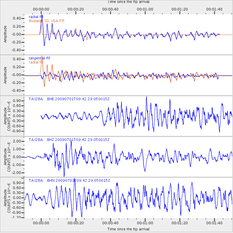
Signal To Noise
| Channel | StoN | STA | LTA |
| TA:I28A: :BHZ:20090701T09:42:29.050015Z | 3.1570349 | 2.0484183E-7 | 6.488424E-8 |
| TA:I28A: :BHN:20090701T09:42:29.050015Z | 1.0966612 | 2.0249048E-7 | 1.846427E-7 |
| TA:I28A: :BHE:20090701T09:42:29.050015Z | 1.33146 | 1.5408968E-7 | 1.1572986E-7 |
| Arrivals |
| Ps | 0.9 SECOND |
| PpPs | 3.9 SECOND |
| PsPs/PpSs | 4.9 SECOND |


