You are here: Home > Network List > CI - Caltech Regional Seismic Network Stations List
> Station MPM Manuel Prospect Mine, California, USA > Earthquake Result Viewer
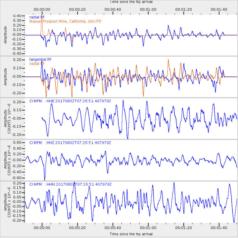
MPM Manuel Prospect Mine, California, USA - Earthquake Result Viewer
*The percent match for this event was below the threshold and hence no stack was calculated.
| Earthquake location: |
Chile-Argentina Border Region |
| Earthquake latitude/longitude: |
-33.2/-70.6 |
| Earthquake time(UTC): |
2017/08/02 (214) 07:15:13 GMT |
| Earthquake Depth: |
88 km |
| Earthquake Magnitude: |
5.5 Mww |
| Earthquake Catalog/Contributor: |
NEIC PDE/us |
|
| Network: |
CI Caltech Regional Seismic Network |
| Station: |
MPM Manuel Prospect Mine, California, USA |
| Lat/Lon: |
36.06 N/117.49 W |
| Elevation: |
185 m |
|
| Distance: |
81.7 deg |
| Az: |
323.307 deg |
| Baz: |
141.814 deg |
| Ray Param: |
$rayparam |
*The percent match for this event was below the threshold and hence was not used in the summary stack. |
|
| Radial Match: |
68.96003 % |
| Radial Bump: |
400 |
| Transverse Match: |
55.531544 % |
| Transverse Bump: |
400 |
| SOD ConfigId: |
13570011 |
| Insert Time: |
2019-04-28 12:44:39.322 +0000 |
| GWidth: |
2.5 |
| Max Bumps: |
400 |
| Tol: |
0.001 |
|
Signal To Noise
| Channel | StoN | STA | LTA |
| CI:MPM: :HHZ:20170802T07:26:51.407979Z | 2.747407 | 2.5966898E-7 | 9.4514206E-8 |
| CI:MPM: :HHN:20170802T07:26:51.407979Z | 1.1705381 | 7.909449E-8 | 6.757105E-8 |
| CI:MPM: :HHE:20170802T07:26:51.407979Z | 0.7083583 | 5.5477514E-8 | 7.8318436E-8 |
| Arrivals |
| Ps | |
| PpPs | |
| PsPs/PpSs | |


