You are here: Home > Network List > TA - USArray Transportable Network (new EarthScope stations) Stations List
> Station I28A Midland, SD, USA > Earthquake Result Viewer
I28A Midland, SD, USA - Earthquake Result Viewer
*The percent match for this event was below the threshold and hence no stack was calculated.
| Earthquake location: |
Volcano Islands, Japan Region |
| Earthquake latitude/longitude: |
22.6/143.3 |
| Earthquake time(UTC): |
2009/07/29 (210) 14:52:08 GMT |
| Earthquake Depth: |
140 km |
| Earthquake Magnitude: |
5.5 MW, 5.2 MB, 5.4 MW |
| Earthquake Catalog/Contributor: |
WHDF/NEIC |
|
| Network: |
TA USArray Transportable Network (new EarthScope stations) |
| Station: |
I28A Midland, SD, USA |
| Lat/Lon: |
44.00 N/101.17 W |
| Elevation: |
655 m |
|
| Distance: |
91.4 deg |
| Az: |
40.631 deg |
| Baz: |
303.485 deg |
| Ray Param: |
$rayparam |
*The percent match for this event was below the threshold and hence was not used in the summary stack. |
|
| Radial Match: |
61.418827 % |
| Radial Bump: |
400 |
| Transverse Match: |
52.364967 % |
| Transverse Bump: |
373 |
| SOD ConfigId: |
2622 |
| Insert Time: |
2010-03-06 02:32:03.286 +0000 |
| GWidth: |
2.5 |
| Max Bumps: |
400 |
| Tol: |
0.001 |
|
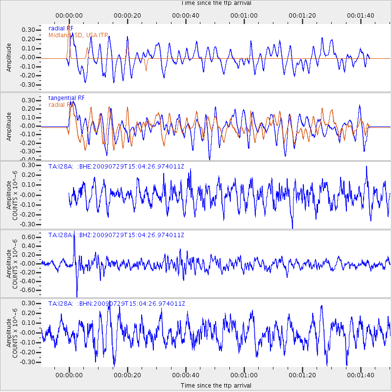
Signal To Noise
| Channel | StoN | STA | LTA |
| TA:I28A: :BHZ:20090729T15:04:26.974011Z | 4.7133465 | 2.4681813E-7 | 5.2365795E-8 |
| TA:I28A: :BHN:20090729T15:04:26.974011Z | 0.77016956 | 7.935852E-8 | 1.03040335E-7 |
| TA:I28A: :BHE:20090729T15:04:26.974011Z | 1.0620358 | 8.852614E-8 | 8.335515E-8 |
| Arrivals |
| Ps | |
| PpPs | |
| PsPs/PpSs | |


