You are here: Home > Network List > TA - USArray Transportable Network (new EarthScope stations) Stations List
> Station I28A Midland, SD, USA > Earthquake Result Viewer
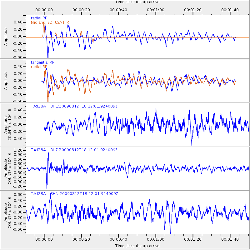
I28A Midland, SD, USA - Earthquake Result Viewer
*The percent match for this event was below the threshold and hence no stack was calculated.
| Earthquake location: |
Catamarca Province, Argentina |
| Earthquake latitude/longitude: |
-27.9/-66.7 |
| Earthquake time(UTC): |
2009/08/12 (224) 18:00:52 GMT |
| Earthquake Depth: |
174 km |
| Earthquake Magnitude: |
5.5 MW, 5.3 MB, 5.5 MW |
| Earthquake Catalog/Contributor: |
WHDF/NEIC |
|
| Network: |
TA USArray Transportable Network (new EarthScope stations) |
| Station: |
I28A Midland, SD, USA |
| Lat/Lon: |
44.00 N/101.17 W |
| Elevation: |
655 m |
|
| Distance: |
78.2 deg |
| Az: |
335.321 deg |
| Baz: |
149.196 deg |
| Ray Param: |
$rayparam |
*The percent match for this event was below the threshold and hence was not used in the summary stack. |
|
| Radial Match: |
54.689037 % |
| Radial Bump: |
400 |
| Transverse Match: |
59.27462 % |
| Transverse Bump: |
400 |
| SOD ConfigId: |
2622 |
| Insert Time: |
2010-03-06 02:32:05.173 +0000 |
| GWidth: |
2.5 |
| Max Bumps: |
400 |
| Tol: |
0.001 |
|
Signal To Noise
| Channel | StoN | STA | LTA |
| TA:I28A: :BHZ:20090812T18:12:01.924009Z | 9.677608 | 4.6574962E-7 | 4.8126523E-8 |
| TA:I28A: :BHN:20090812T18:12:01.924009Z | 1.6692613 | 2.7616122E-7 | 1.6543919E-7 |
| TA:I28A: :BHE:20090812T18:12:01.924009Z | 1.7234257 | 1.973122E-7 | 1.14488365E-7 |
| Arrivals |
| Ps | |
| PpPs | |
| PsPs/PpSs | |


