You are here: Home > Network List > TA - USArray Transportable Network (new EarthScope stations) Stations List
> Station I28A Midland, SD, USA > Earthquake Result Viewer
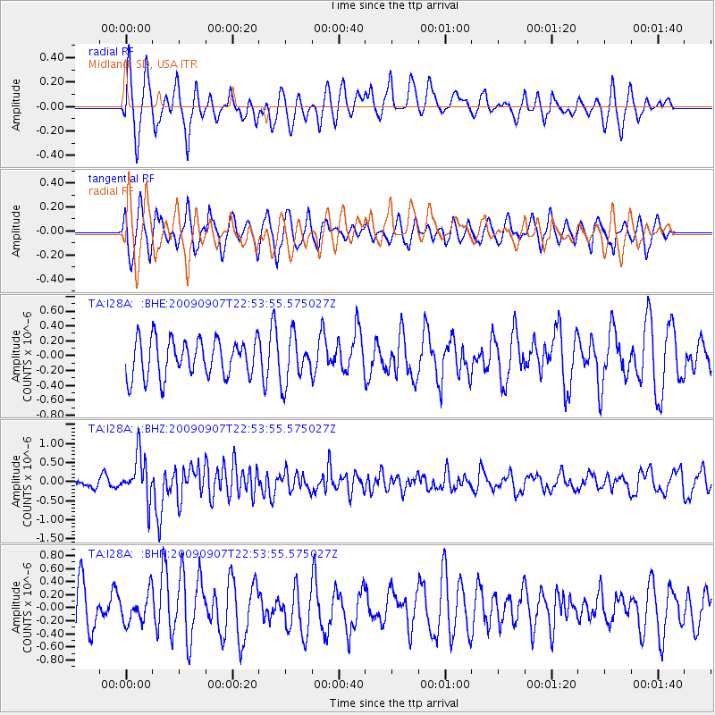
I28A Midland, SD, USA - Earthquake Result Viewer
*The percent match for this event was below the threshold and hence no stack was calculated.
| Earthquake location: |
Northwestern Caucasus |
| Earthquake latitude/longitude: |
42.7/43.4 |
| Earthquake time(UTC): |
2009/09/07 (250) 22:41:37 GMT |
| Earthquake Depth: |
15 km |
| Earthquake Magnitude: |
5.7 MB, 5.8 MS, 6.0 MW, 5.9 MW |
| Earthquake Catalog/Contributor: |
WHDF/NEIC |
|
| Network: |
TA USArray Transportable Network (new EarthScope stations) |
| Station: |
I28A Midland, SD, USA |
| Lat/Lon: |
44.00 N/101.17 W |
| Elevation: |
655 m |
|
| Distance: |
88.1 deg |
| Az: |
335.282 deg |
| Baz: |
25.304 deg |
| Ray Param: |
$rayparam |
*The percent match for this event was below the threshold and hence was not used in the summary stack. |
|
| Radial Match: |
61.17432 % |
| Radial Bump: |
400 |
| Transverse Match: |
56.657078 % |
| Transverse Bump: |
387 |
| SOD ConfigId: |
2622 |
| Insert Time: |
2010-03-06 02:32:09.121 +0000 |
| GWidth: |
2.5 |
| Max Bumps: |
400 |
| Tol: |
0.001 |
|
Signal To Noise
| Channel | StoN | STA | LTA |
| TA:I28A: :BHZ:20090907T22:53:55.575027Z | 4.7855773 | 5.892074E-7 | 1.2312148E-7 |
| TA:I28A: :BHN:20090907T22:53:55.575027Z | 0.5081677 | 2.2473895E-7 | 4.422535E-7 |
| TA:I28A: :BHE:20090907T22:53:55.575027Z | 1.2555611 | 3.1451407E-7 | 2.5049684E-7 |
| Arrivals |
| Ps | |
| PpPs | |
| PsPs/PpSs | |


