You are here: Home > Network List > TA - USArray Transportable Network (new EarthScope stations) Stations List
> Station I20A Worland, WY, USA > Earthquake Result Viewer
I20A Worland, WY, USA - Earthquake Result Viewer
| Earthquake location: |
Norwegian Sea |
| Earthquake latitude/longitude: |
72.2/0.9 |
| Earthquake time(UTC): |
2009/08/20 (232) 06:35:04 GMT |
| Earthquake Depth: |
6.0 km |
| Earthquake Magnitude: |
5.9 MB, 5.7 MS, 6.0 MW, 6.0 MW |
| Earthquake Catalog/Contributor: |
WHDF/NEIC |
|
| Network: |
TA USArray Transportable Network (new EarthScope stations) |
| Station: |
I20A Worland, WY, USA |
| Lat/Lon: |
43.95 N/108.13 W |
| Elevation: |
1342 m |
|
| Distance: |
54.2 deg |
| Az: |
302.643 deg |
| Baz: |
21.012 deg |
| Ray Param: |
0.06562947 |
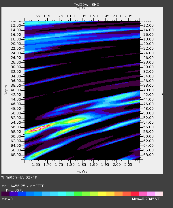
| Estimated Moho Depth: |
56.25 km |
| Estimated Crust Vp/Vs: |
1.67 |
| Assumed Crust Vp: |
6.161 km/s |
| Estimated Crust Vs: |
3.695 km/s |
| Estimated Crust Poisson's Ratio: |
0.22 |
|
| Radial Match: |
83.62749 % |
| Radial Bump: |
400 |
| Transverse Match: |
69.657646 % |
| Transverse Bump: |
400 |
| SOD ConfigId: |
2622 |
| Insert Time: |
2010-03-06 02:32:32.356 +0000 |
| GWidth: |
2.5 |
| Max Bumps: |
400 |
| Tol: |
0.001 |
|
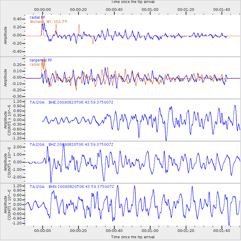
Signal To Noise
| Channel | StoN | STA | LTA |
| TA:I20A: :BHZ:20090820T06:43:59.375007Z | 11.197688 | 1.0273105E-6 | 9.174309E-8 |
| TA:I20A: :BHN:20090820T06:43:59.375007Z | 3.3252623 | 3.8312578E-7 | 1.1521671E-7 |
| TA:I20A: :BHE:20090820T06:43:59.375007Z | 1.401652 | 1.756158E-7 | 1.25292E-7 |
| Arrivals |
| Ps | 6.4 SECOND |
| PpPs | 23 SECOND |
| PsPs/PpSs | 30 SECOND |


