You are here: Home > Network List > TA - USArray Transportable Network (new EarthScope stations) Stations List
> Station I20A Worland, WY, USA > Earthquake Result Viewer
I20A Worland, WY, USA - Earthquake Result Viewer
| Earthquake location: |
Kuril Islands |
| Earthquake latitude/longitude: |
48.3/154.2 |
| Earthquake time(UTC): |
2009/09/10 (253) 02:46:50 GMT |
| Earthquake Depth: |
36 km |
| Earthquake Magnitude: |
6.0 MB, 5.5 MS, 6.0 MW, 5.8 MW |
| Earthquake Catalog/Contributor: |
WHDF/NEIC |
|
| Network: |
TA USArray Transportable Network (new EarthScope stations) |
| Station: |
I20A Worland, WY, USA |
| Lat/Lon: |
43.95 N/108.13 W |
| Elevation: |
1342 m |
|
| Distance: |
63.2 deg |
| Az: |
53.301 deg |
| Baz: |
312.185 deg |
| Ray Param: |
0.059655603 |
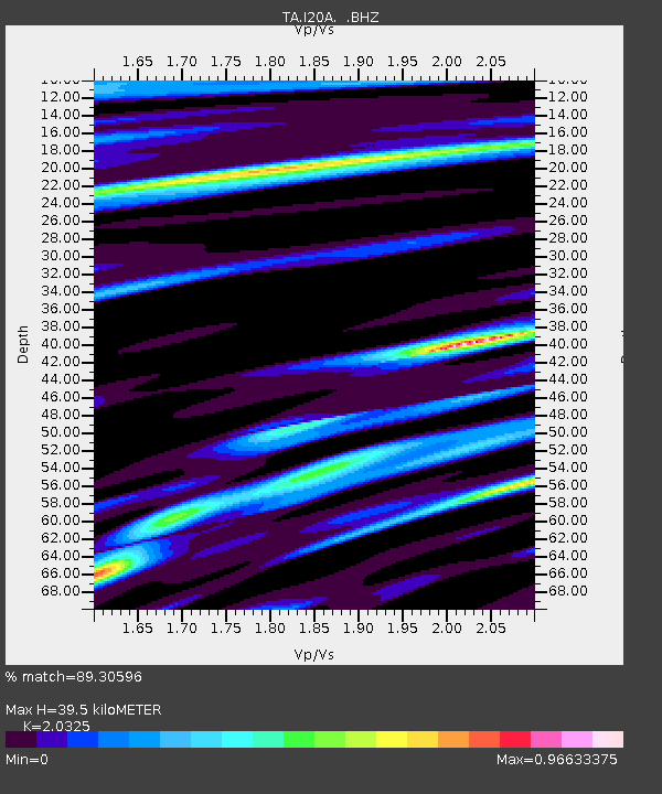
| Estimated Moho Depth: |
39.5 km |
| Estimated Crust Vp/Vs: |
2.03 |
| Assumed Crust Vp: |
6.161 km/s |
| Estimated Crust Vs: |
3.031 km/s |
| Estimated Crust Poisson's Ratio: |
0.34 |
|
| Radial Match: |
89.30596 % |
| Radial Bump: |
400 |
| Transverse Match: |
76.0045 % |
| Transverse Bump: |
386 |
| SOD ConfigId: |
2622 |
| Insert Time: |
2010-03-06 02:32:34.579 +0000 |
| GWidth: |
2.5 |
| Max Bumps: |
400 |
| Tol: |
0.001 |
|
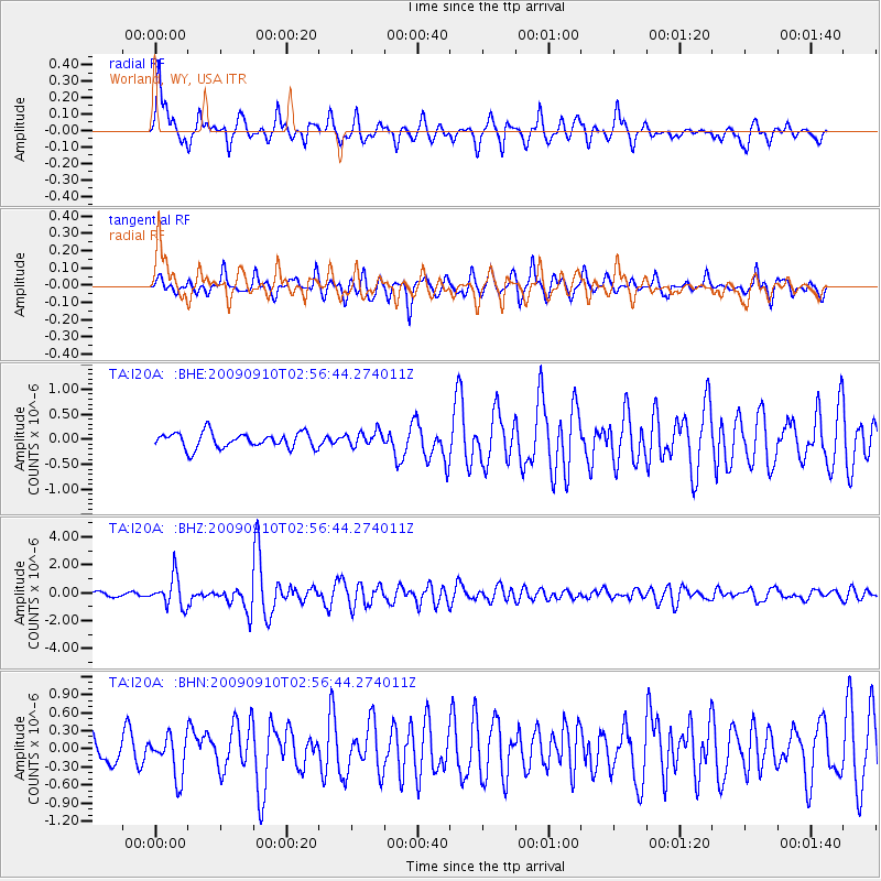
Signal To Noise
| Channel | StoN | STA | LTA |
| TA:I20A: :BHZ:20090910T02:56:44.274011Z | 6.8053994 | 1.0741771E-6 | 1.578419E-7 |
| TA:I20A: :BHN:20090910T02:56:44.274011Z | 1.7592316 | 3.4175764E-7 | 1.942653E-7 |
| TA:I20A: :BHE:20090910T02:56:44.274011Z | 0.9599512 | 1.4744066E-7 | 1.5359183E-7 |
| Arrivals |
| Ps | 6.9 SECOND |
| PpPs | 19 SECOND |
| PsPs/PpSs | 26 SECOND |


