You are here: Home > Network List > TA - USArray Transportable Network (new EarthScope stations) Stations List
> Station I20A Worland, WY, USA > Earthquake Result Viewer
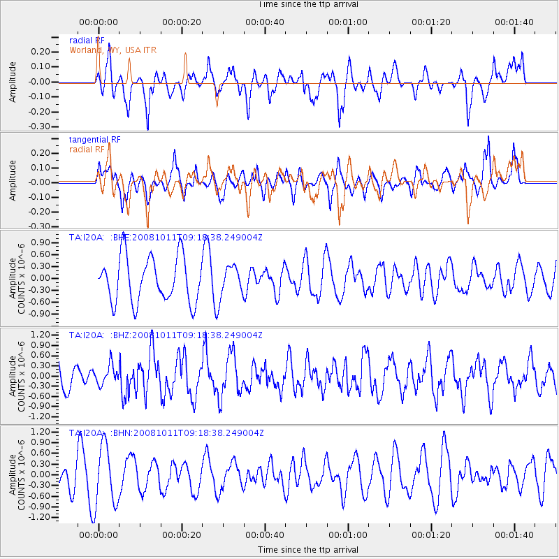
I20A Worland, WY, USA - Earthquake Result Viewer
*The percent match for this event was below the threshold and hence no stack was calculated.
| Earthquake location: |
Eastern Caucasus |
| Earthquake latitude/longitude: |
43.4/46.3 |
| Earthquake time(UTC): |
2008/10/11 (285) 09:06:10 GMT |
| Earthquake Depth: |
16 km |
| Earthquake Magnitude: |
5.6 MB, 5.5 MS, 5.8 MW, 5.7 MW |
| Earthquake Catalog/Contributor: |
WHDF/NEIC |
|
| Network: |
TA USArray Transportable Network (new EarthScope stations) |
| Station: |
I20A Worland, WY, USA |
| Lat/Lon: |
43.95 N/108.13 W |
| Elevation: |
1342 m |
|
| Distance: |
90.1 deg |
| Az: |
341.803 deg |
| Baz: |
18.378 deg |
| Ray Param: |
$rayparam |
*The percent match for this event was below the threshold and hence was not used in the summary stack. |
|
| Radial Match: |
46.30314 % |
| Radial Bump: |
400 |
| Transverse Match: |
57.42884 % |
| Transverse Bump: |
400 |
| SOD ConfigId: |
2556 |
| Insert Time: |
2010-03-06 02:33:05.214 +0000 |
| GWidth: |
2.5 |
| Max Bumps: |
400 |
| Tol: |
0.001 |
|
Signal To Noise
| Channel | StoN | STA | LTA |
| TA:I20A: :BHZ:20081011T09:18:38.249004Z | 0.7756753 | 2.91197E-7 | 3.7541096E-7 |
| TA:I20A: :BHN:20081011T09:18:38.249004Z | 2.9505982 | 8.2660586E-7 | 2.8014856E-7 |
| TA:I20A: :BHE:20081011T09:18:38.249004Z | 0.59061897 | 3.3717689E-7 | 5.708873E-7 |
| Arrivals |
| Ps | |
| PpPs | |
| PsPs/PpSs | |


