You are here: Home > Network List > TA - USArray Transportable Network (new EarthScope stations) Stations List
> Station I20A Worland, WY, USA > Earthquake Result Viewer
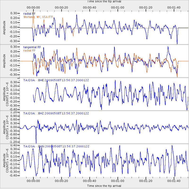
I20A Worland, WY, USA - Earthquake Result Viewer
*The percent match for this event was below the threshold and hence no stack was calculated.
| Earthquake location: |
Mendoza Province, Argentina |
| Earthquake latitude/longitude: |
-32.1/-69.7 |
| Earthquake time(UTC): |
2009/05/08 (128) 13:44:53 GMT |
| Earthquake Depth: |
112 km |
| Earthquake Magnitude: |
5.6 MB, 5.4 MW |
| Earthquake Catalog/Contributor: |
WHDF/NEIC |
|
| Network: |
TA USArray Transportable Network (new EarthScope stations) |
| Station: |
I20A Worland, WY, USA |
| Lat/Lon: |
43.95 N/108.13 W |
| Elevation: |
1342 m |
|
| Distance: |
83.4 deg |
| Az: |
333.119 deg |
| Baz: |
147.891 deg |
| Ray Param: |
$rayparam |
*The percent match for this event was below the threshold and hence was not used in the summary stack. |
|
| Radial Match: |
48.734642 % |
| Radial Bump: |
400 |
| Transverse Match: |
53.198753 % |
| Transverse Bump: |
400 |
| SOD ConfigId: |
2658 |
| Insert Time: |
2010-03-06 02:33:08.112 +0000 |
| GWidth: |
2.5 |
| Max Bumps: |
400 |
| Tol: |
0.001 |
|
Signal To Noise
| Channel | StoN | STA | LTA |
| TA:I20A: :BHZ:20090508T13:56:37.200012Z | 4.2649603 | 3.5398975E-7 | 8.299954E-8 |
| TA:I20A: :BHN:20090508T13:56:37.200012Z | 2.4641094 | 2.6112028E-7 | 1.0596943E-7 |
| TA:I20A: :BHE:20090508T13:56:37.200012Z | 0.89280415 | 1.2702591E-7 | 1.4227746E-7 |
| Arrivals |
| Ps | |
| PpPs | |
| PsPs/PpSs | |


