You are here: Home > Network List > TA - USArray Transportable Network (new EarthScope stations) Stations List
> Station I20A Worland, WY, USA > Earthquake Result Viewer
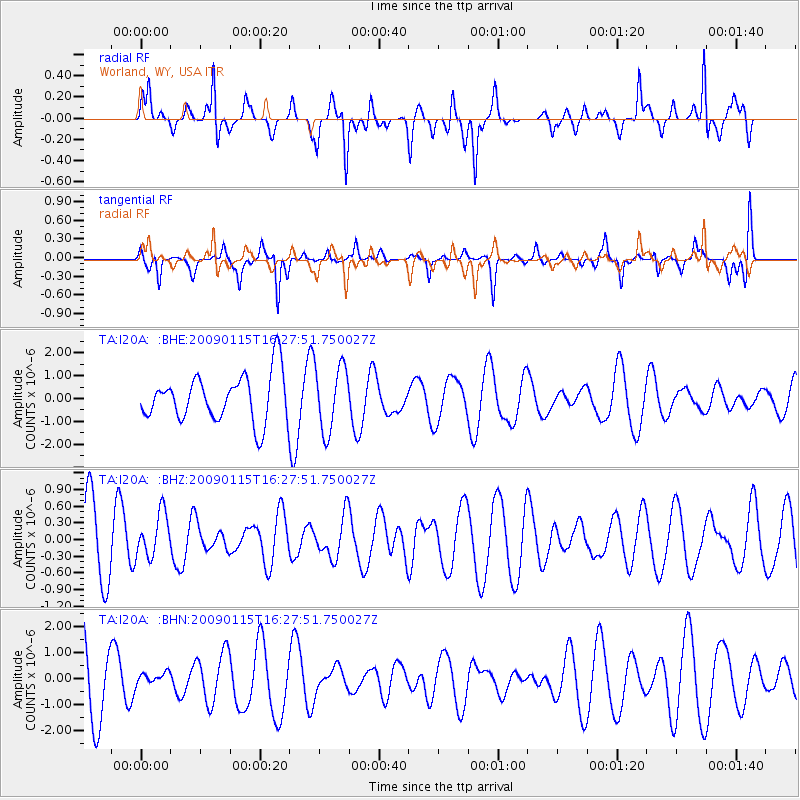
I20A Worland, WY, USA - Earthquake Result Viewer
*The percent match for this event was below the threshold and hence no stack was calculated.
| Earthquake location: |
Solomon Islands |
| Earthquake latitude/longitude: |
-10.3/161.2 |
| Earthquake time(UTC): |
2009/01/15 (015) 16:15:01 GMT |
| Earthquake Depth: |
114 km |
| Earthquake Magnitude: |
5.6 MB, 5.7 MW, 5.7 MW |
| Earthquake Catalog/Contributor: |
WHDF/NEIC |
|
| Network: |
TA USArray Transportable Network (new EarthScope stations) |
| Station: |
I20A Worland, WY, USA |
| Lat/Lon: |
43.95 N/108.13 W |
| Elevation: |
1342 m |
|
| Distance: |
97.6 deg |
| Az: |
46.765 deg |
| Baz: |
262.996 deg |
| Ray Param: |
$rayparam |
*The percent match for this event was below the threshold and hence was not used in the summary stack. |
|
| Radial Match: |
59.164013 % |
| Radial Bump: |
266 |
| Transverse Match: |
47.207077 % |
| Transverse Bump: |
255 |
| SOD ConfigId: |
2834 |
| Insert Time: |
2010-03-06 02:33:08.774 +0000 |
| GWidth: |
2.5 |
| Max Bumps: |
400 |
| Tol: |
0.001 |
|
Signal To Noise
| Channel | StoN | STA | LTA |
| TA:I20A: :BHZ:20090115T16:27:51.750027Z | 0.7911918 | 3.9663243E-7 | 5.0131007E-7 |
| TA:I20A: :BHN:20090115T16:27:51.750027Z | 0.1726221 | 2.6862753E-7 | 1.5561595E-6 |
| TA:I20A: :BHE:20090115T16:27:51.750027Z | 1.3779243 | 1.4279558E-6 | 1.0363092E-6 |
| Arrivals |
| Ps | |
| PpPs | |
| PsPs/PpSs | |


