You are here: Home > Network List > TA - USArray Transportable Network (new EarthScope stations) Stations List
> Station I20A Worland, WY, USA > Earthquake Result Viewer
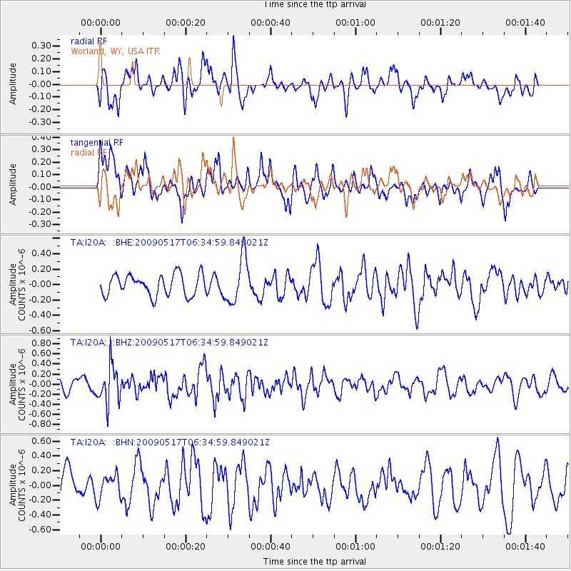
I20A Worland, WY, USA - Earthquake Result Viewer
*The percent match for this event was below the threshold and hence no stack was calculated.
| Earthquake location: |
Tonga Islands |
| Earthquake latitude/longitude: |
-16.8/-173.5 |
| Earthquake time(UTC): |
2009/05/17 (137) 06:23:03 GMT |
| Earthquake Depth: |
67 km |
| Earthquake Magnitude: |
5.5 MB, 5.6 MW, 5.6 MW |
| Earthquake Catalog/Contributor: |
WHDF/NEIC |
|
| Network: |
TA USArray Transportable Network (new EarthScope stations) |
| Station: |
I20A Worland, WY, USA |
| Lat/Lon: |
43.95 N/108.13 W |
| Elevation: |
1342 m |
|
| Distance: |
84.9 deg |
| Az: |
41.236 deg |
| Baz: |
240.932 deg |
| Ray Param: |
$rayparam |
*The percent match for this event was below the threshold and hence was not used in the summary stack. |
|
| Radial Match: |
46.23375 % |
| Radial Bump: |
400 |
| Transverse Match: |
48.9124 % |
| Transverse Bump: |
400 |
| SOD ConfigId: |
2760 |
| Insert Time: |
2010-03-06 02:33:11.841 +0000 |
| GWidth: |
2.5 |
| Max Bumps: |
400 |
| Tol: |
0.001 |
|
Signal To Noise
| Channel | StoN | STA | LTA |
| TA:I20A: :BHZ:20090517T06:34:59.849021Z | 3.0235198 | 3.7507502E-7 | 1.2405245E-7 |
| TA:I20A: :BHN:20090517T06:34:59.849021Z | 0.70528334 | 1.6208048E-7 | 2.2980902E-7 |
| TA:I20A: :BHE:20090517T06:34:59.849021Z | 2.2585394 | 3.0590695E-7 | 1.354446E-7 |
| Arrivals |
| Ps | |
| PpPs | |
| PsPs/PpSs | |


