You are here: Home > Network List > TA - USArray Transportable Network (new EarthScope stations) Stations List
> Station I20A Worland, WY, USA > Earthquake Result Viewer
I20A Worland, WY, USA - Earthquake Result Viewer
*The percent match for this event was below the threshold and hence no stack was calculated.
| Earthquake location: |
Easter Island Region |
| Earthquake latitude/longitude: |
-28.5/-112.8 |
| Earthquake time(UTC): |
2008/08/19 (232) 10:58:00 GMT |
| Earthquake Depth: |
9.0 km |
| Earthquake Magnitude: |
5.5 MB, 5.3 MS, 5.7 MW, 5.7 MW |
| Earthquake Catalog/Contributor: |
WHDF/NEIC |
|
| Network: |
TA USArray Transportable Network (new EarthScope stations) |
| Station: |
I20A Worland, WY, USA |
| Lat/Lon: |
43.95 N/108.13 W |
| Elevation: |
1342 m |
|
| Distance: |
72.3 deg |
| Az: |
3.573 deg |
| Baz: |
184.353 deg |
| Ray Param: |
$rayparam |
*The percent match for this event was below the threshold and hence was not used in the summary stack. |
|
| Radial Match: |
69.715515 % |
| Radial Bump: |
349 |
| Transverse Match: |
73.52452 % |
| Transverse Bump: |
400 |
| SOD ConfigId: |
2504 |
| Insert Time: |
2010-03-06 02:33:16.211 +0000 |
| GWidth: |
2.5 |
| Max Bumps: |
400 |
| Tol: |
0.001 |
|
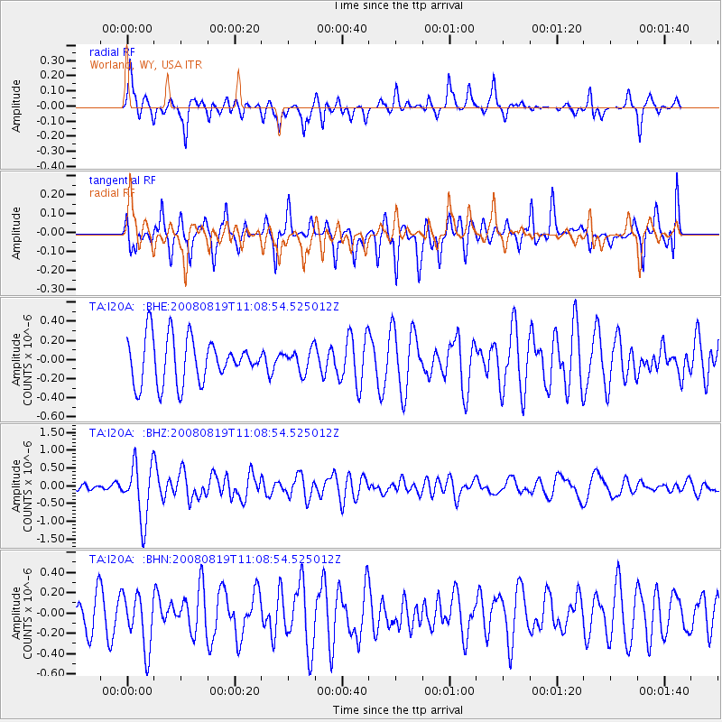
Signal To Noise
| Channel | StoN | STA | LTA |
| TA:I20A: :BHZ:20080819T11:08:54.525012Z | 8.884188 | 7.951975E-7 | 8.950706E-8 |
| TA:I20A: :BHN:20080819T11:08:54.525012Z | 1.5888691 | 2.6992547E-7 | 1.6988527E-7 |
| TA:I20A: :BHE:20080819T11:08:54.525012Z | 0.49697092 | 1.1685132E-7 | 2.3512708E-7 |
| Arrivals |
| Ps | |
| PpPs | |
| PsPs/PpSs | |


