You are here: Home > Network List > TA - USArray Transportable Network (new EarthScope stations) Stations List
> Station I20A Worland, WY, USA > Earthquake Result Viewer
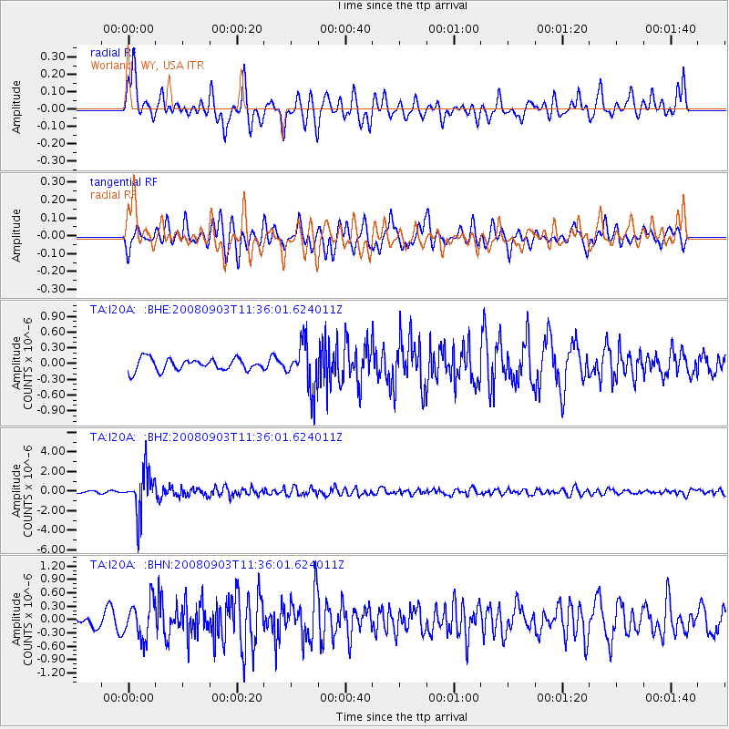
I20A Worland, WY, USA - Earthquake Result Viewer
*The percent match for this event was below the threshold and hence no stack was calculated.
| Earthquake location: |
Santiago Del Estero Prov., Arg. |
| Earthquake latitude/longitude: |
-26.7/-63.2 |
| Earthquake time(UTC): |
2008/09/03 (247) 11:25:14 GMT |
| Earthquake Depth: |
570 km |
| Earthquake Magnitude: |
5.9 MB, 6.3 MW, 6.3 MW |
| Earthquake Catalog/Contributor: |
WHDF/NEIC |
|
| Network: |
TA USArray Transportable Network (new EarthScope stations) |
| Station: |
I20A Worland, WY, USA |
| Lat/Lon: |
43.95 N/108.13 W |
| Elevation: |
1342 m |
|
| Distance: |
81.5 deg |
| Az: |
328.966 deg |
| Baz: |
140.333 deg |
| Ray Param: |
$rayparam |
*The percent match for this event was below the threshold and hence was not used in the summary stack. |
|
| Radial Match: |
76.38225 % |
| Radial Bump: |
400 |
| Transverse Match: |
73.42135 % |
| Transverse Bump: |
400 |
| SOD ConfigId: |
2504 |
| Insert Time: |
2010-03-06 02:33:22.790 +0000 |
| GWidth: |
2.5 |
| Max Bumps: |
400 |
| Tol: |
0.001 |
|
Signal To Noise
| Channel | StoN | STA | LTA |
| TA:I20A: :BHZ:20080903T11:36:01.624011Z | 24.192303 | 2.154102E-6 | 8.9040796E-8 |
| TA:I20A: :BHN:20080903T11:36:01.624011Z | 3.3028882 | 4.134026E-7 | 1.2516396E-7 |
| TA:I20A: :BHE:20080903T11:36:01.624011Z | 3.9021342 | 4.452231E-7 | 1.1409733E-7 |
| Arrivals |
| Ps | |
| PpPs | |
| PsPs/PpSs | |


