You are here: Home > Network List > TA - USArray Transportable Network (new EarthScope stations) Stations List
> Station I20A Worland, WY, USA > Earthquake Result Viewer
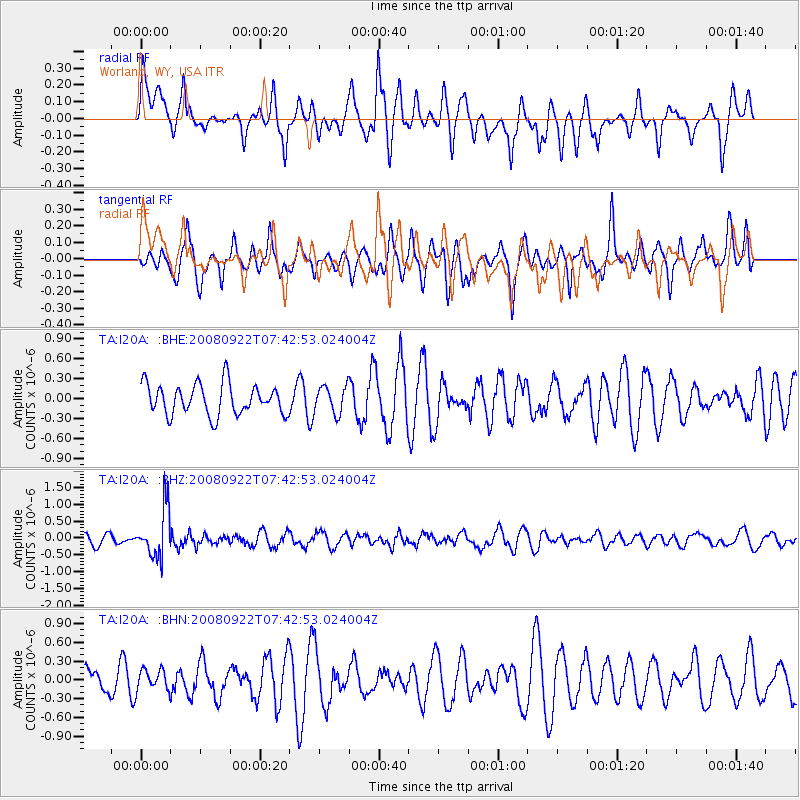
I20A Worland, WY, USA - Earthquake Result Viewer
*The percent match for this event was below the threshold and hence no stack was calculated.
| Earthquake location: |
Hokkaido, Japan Region |
| Earthquake latitude/longitude: |
41.6/140.4 |
| Earthquake time(UTC): |
2008/09/22 (266) 07:31:59 GMT |
| Earthquake Depth: |
149 km |
| Earthquake Magnitude: |
5.7 MW, 5.3 MB, 5.6 MW |
| Earthquake Catalog/Contributor: |
WHDF/NEIC |
|
| Network: |
TA USArray Transportable Network (new EarthScope stations) |
| Station: |
I20A Worland, WY, USA |
| Lat/Lon: |
43.95 N/108.13 W |
| Elevation: |
1342 m |
|
| Distance: |
75.0 deg |
| Az: |
44.123 deg |
| Baz: |
313.683 deg |
| Ray Param: |
$rayparam |
*The percent match for this event was below the threshold and hence was not used in the summary stack. |
|
| Radial Match: |
50.8498 % |
| Radial Bump: |
392 |
| Transverse Match: |
52.43023 % |
| Transverse Bump: |
390 |
| SOD ConfigId: |
2560 |
| Insert Time: |
2010-03-06 02:33:26.065 +0000 |
| GWidth: |
2.5 |
| Max Bumps: |
400 |
| Tol: |
0.001 |
|
Signal To Noise
| Channel | StoN | STA | LTA |
| TA:I20A: :BHZ:20080922T07:42:53.024004Z | 3.015154 | 7.188637E-7 | 2.3841692E-7 |
| TA:I20A: :BHN:20080922T07:42:53.024004Z | 0.45256642 | 1.6543083E-7 | 3.6553934E-7 |
| TA:I20A: :BHE:20080922T07:42:53.024004Z | 0.89929235 | 2.0768954E-7 | 2.3094773E-7 |
| Arrivals |
| Ps | |
| PpPs | |
| PsPs/PpSs | |


