You are here: Home > Network List > CU - Caribbean Network (USGS) Stations List
> Station GTBY Guantanamo Bay, Cuba > Earthquake Result Viewer
GTBY Guantanamo Bay, Cuba - Earthquake Result Viewer
| Earthquake location: |
Off Coast Of Jalisco, Mexico |
| Earthquake latitude/longitude: |
18.8/-107.0 |
| Earthquake time(UTC): |
2016/01/21 (021) 18:06:59 GMT |
| Earthquake Depth: |
10 km |
| Earthquake Magnitude: |
6.6 MWW, 6.9 MI |
| Earthquake Catalog/Contributor: |
NEIC PDE/NEIC COMCAT |
|
| Network: |
CU Caribbean Network (USGS) |
| Station: |
GTBY Guantanamo Bay, Cuba |
| Lat/Lon: |
19.93 N/75.11 W |
| Elevation: |
79 m |
|
| Distance: |
30.0 deg |
| Az: |
82.619 deg |
| Baz: |
273.373 deg |
| Ray Param: |
0.07943784 |
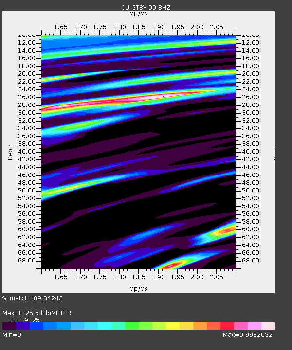
| Estimated Moho Depth: |
25.5 km |
| Estimated Crust Vp/Vs: |
1.91 |
| Assumed Crust Vp: |
6.048 km/s |
| Estimated Crust Vs: |
3.162 km/s |
| Estimated Crust Poisson's Ratio: |
0.31 |
|
| Radial Match: |
89.84243 % |
| Radial Bump: |
289 |
| Transverse Match: |
60.807148 % |
| Transverse Bump: |
400 |
| SOD ConfigId: |
1399611 |
| Insert Time: |
2016-02-04 18:45:50.150 +0000 |
| GWidth: |
2.5 |
| Max Bumps: |
400 |
| Tol: |
0.001 |
|

Signal To Noise
| Channel | StoN | STA | LTA |
| CU:GTBY:00:BHZ:20160121T18:12:37.37499Z | 2.6532195 | 1.2280071E-6 | 4.6283662E-7 |
| CU:GTBY:00:BH1:20160121T18:12:37.37499Z | 2.3158972 | 9.1380593E-7 | 3.9457964E-7 |
| CU:GTBY:00:BH2:20160121T18:12:37.37499Z | 0.939025 | 4.7436484E-7 | 5.051674E-7 |
| Arrivals |
| Ps | 4.1 SECOND |
| PpPs | 12 SECOND |
| PsPs/PpSs | 16 SECOND |


