You are here: Home > Network List > GT - Global Telemetered Seismograph Network (USAF/USGS) Stations List
> Station LPAZ La Paz , Bolivia > Earthquake Result Viewer
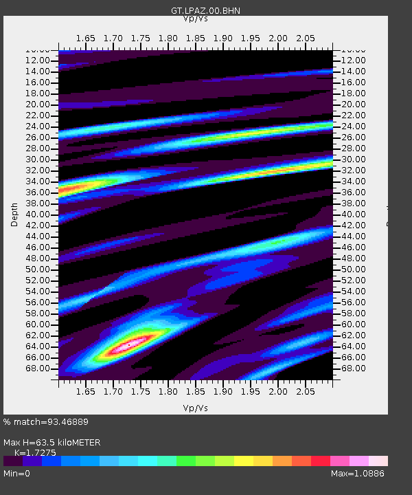
LPAZ La Paz , Bolivia - Earthquake Result Viewer
| Earthquake location: |
Off Coast Of Jalisco, Mexico |
| Earthquake latitude/longitude: |
18.8/-107.0 |
| Earthquake time(UTC): |
2016/01/21 (021) 18:06:59 GMT |
| Earthquake Depth: |
10 km |
| Earthquake Magnitude: |
6.6 MWW, 6.9 MI |
| Earthquake Catalog/Contributor: |
NEIC PDE/NEIC COMCAT |
|
| Network: |
GT Global Telemetered Seismograph Network (USAF/USGS) |
| Station: |
LPAZ La Paz , Bolivia |
| Lat/Lon: |
16.17 S/68.08 W |
| Elevation: |
4817 m |
|
| Distance: |
51.7 deg |
| Az: |
129.79 deg |
| Baz: |
310.772 deg |
| Ray Param: |
0.067235686 |
| Estimated Moho Depth: |
63.5 km |
| Estimated Crust Vp/Vs: |
1.73 |
| Assumed Crust Vp: |
6.454 km/s |
| Estimated Crust Vs: |
3.736 km/s |
| Estimated Crust Poisson's Ratio: |
0.25 |
|
| Radial Match: |
93.46889 % |
| Radial Bump: |
346 |
| Transverse Match: |
83.287 % |
| Transverse Bump: |
400 |
| SOD ConfigId: |
1399611 |
| Insert Time: |
2016-02-04 18:46:30.965 +0000 |
| GWidth: |
2.5 |
| Max Bumps: |
400 |
| Tol: |
0.001 |
|

Signal To Noise
| Channel | StoN | STA | LTA |
| GT:LPAZ:00:BHZ:20160121T18:15:35.523977Z | 14.389896 | 6.909528E-7 | 4.8016524E-8 |
| GT:LPAZ:00:BHN:20160121T18:15:35.523977Z | 5.2493973 | 2.8798797E-7 | 5.486115E-8 |
| GT:LPAZ:00:BHE:20160121T18:15:35.523977Z | 3.1834824 | 2.510742E-7 | 7.8867785E-8 |
| Arrivals |
| Ps | 7.6 SECOND |
| PpPs | 25 SECOND |
| PsPs/PpSs | 33 SECOND |


