You are here: Home > Network List > TA - USArray Transportable Network (new EarthScope stations) Stations List
> Station I20A Worland, WY, USA > Earthquake Result Viewer
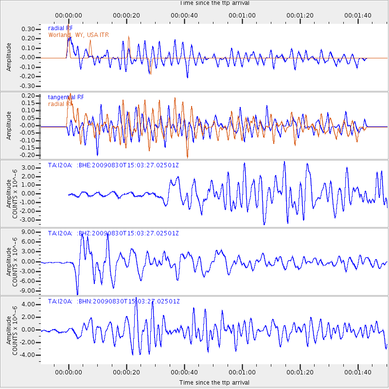
I20A Worland, WY, USA - Earthquake Result Viewer
*The percent match for this event was below the threshold and hence no stack was calculated.
| Earthquake location: |
Samoa Islands Region |
| Earthquake latitude/longitude: |
-15.2/-172.6 |
| Earthquake time(UTC): |
2009/08/30 (242) 14:51:32 GMT |
| Earthquake Depth: |
11 km |
| Earthquake Magnitude: |
6.4 MB, 6.3 MS, 6.6 MW, 6.6 MW |
| Earthquake Catalog/Contributor: |
WHDF/NEIC |
|
| Network: |
TA USArray Transportable Network (new EarthScope stations) |
| Station: |
I20A Worland, WY, USA |
| Lat/Lon: |
43.95 N/108.13 W |
| Elevation: |
1342 m |
|
| Distance: |
83.1 deg |
| Az: |
41.024 deg |
| Baz: |
241.315 deg |
| Ray Param: |
$rayparam |
*The percent match for this event was below the threshold and hence was not used in the summary stack. |
|
| Radial Match: |
78.232216 % |
| Radial Bump: |
400 |
| Transverse Match: |
69.3712 % |
| Transverse Bump: |
400 |
| SOD ConfigId: |
2622 |
| Insert Time: |
2010-03-06 02:33:44.605 +0000 |
| GWidth: |
2.5 |
| Max Bumps: |
400 |
| Tol: |
0.001 |
|
Signal To Noise
| Channel | StoN | STA | LTA |
| TA:I20A: :BHZ:20090830T15:03:27.02501Z | 48.406567 | 4.3532236E-6 | 8.993044E-8 |
| TA:I20A: :BHN:20090830T15:03:27.02501Z | 3.1123383 | 5.856086E-7 | 1.8815712E-7 |
| TA:I20A: :BHE:20090830T15:03:27.02501Z | 3.351898 | 6.2647734E-7 | 1.8690227E-7 |
| Arrivals |
| Ps | |
| PpPs | |
| PsPs/PpSs | |


