You are here: Home > Network List > TA - USArray Transportable Network (new EarthScope stations) Stations List
> Station I20A Worland, WY, USA > Earthquake Result Viewer
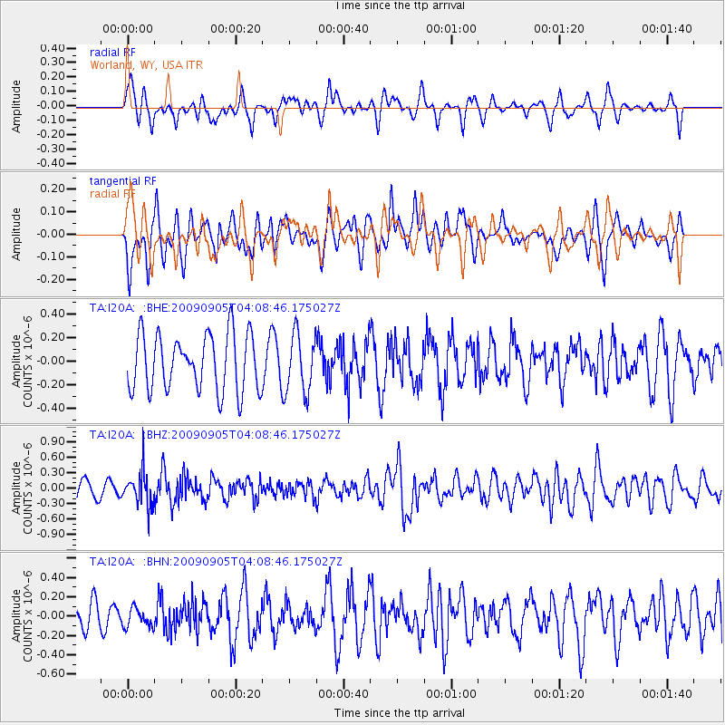
I20A Worland, WY, USA - Earthquake Result Viewer
*The percent match for this event was below the threshold and hence no stack was calculated.
| Earthquake location: |
Southern Peru |
| Earthquake latitude/longitude: |
-15.1/-70.2 |
| Earthquake time(UTC): |
2009/09/05 (248) 03:58:39 GMT |
| Earthquake Depth: |
210 km |
| Earthquake Magnitude: |
5.8 MW, 5.2 MB, 5.8 MW |
| Earthquake Catalog/Contributor: |
WHDF/NEIC |
|
| Network: |
TA USArray Transportable Network (new EarthScope stations) |
| Station: |
I20A Worland, WY, USA |
| Lat/Lon: |
43.95 N/108.13 W |
| Elevation: |
1342 m |
|
| Distance: |
68.2 deg |
| Az: |
331.469 deg |
| Baz: |
140.306 deg |
| Ray Param: |
$rayparam |
*The percent match for this event was below the threshold and hence was not used in the summary stack. |
|
| Radial Match: |
53.474777 % |
| Radial Bump: |
346 |
| Transverse Match: |
45.805454 % |
| Transverse Bump: |
400 |
| SOD ConfigId: |
2622 |
| Insert Time: |
2010-03-06 02:33:46.636 +0000 |
| GWidth: |
2.5 |
| Max Bumps: |
400 |
| Tol: |
0.001 |
|
Signal To Noise
| Channel | StoN | STA | LTA |
| TA:I20A: :BHZ:20090905T04:08:46.175027Z | 2.1441615 | 3.3116484E-7 | 1.544496E-7 |
| TA:I20A: :BHN:20090905T04:08:46.175027Z | 0.6145143 | 9.822201E-8 | 1.5983682E-7 |
| TA:I20A: :BHE:20090905T04:08:46.175027Z | 1.0380576 | 2.4721038E-7 | 2.3814711E-7 |
| Arrivals |
| Ps | |
| PpPs | |
| PsPs/PpSs | |


