You are here: Home > Network List > TA - USArray Transportable Network (new EarthScope stations) Stations List
> Station F20K Avaraart Lake, AK, USA > Earthquake Result Viewer
F20K Avaraart Lake, AK, USA - Earthquake Result Viewer
| Earthquake location: |
Mindanao, Philippines |
| Earthquake latitude/longitude: |
6.2/125.5 |
| Earthquake time(UTC): |
2017/08/05 (217) 00:30:41 GMT |
| Earthquake Depth: |
74 km |
| Earthquake Magnitude: |
5.8 Mww |
| Earthquake Catalog/Contributor: |
NEIC PDE/us |
|
| Network: |
TA USArray Transportable Network (new EarthScope stations) |
| Station: |
F20K Avaraart Lake, AK, USA |
| Lat/Lon: |
67.05 N/155.73 W |
| Elevation: |
136 m |
|
| Distance: |
80.0 deg |
| Az: |
22.997 deg |
| Baz: |
262.084 deg |
| Ray Param: |
0.04844678 |
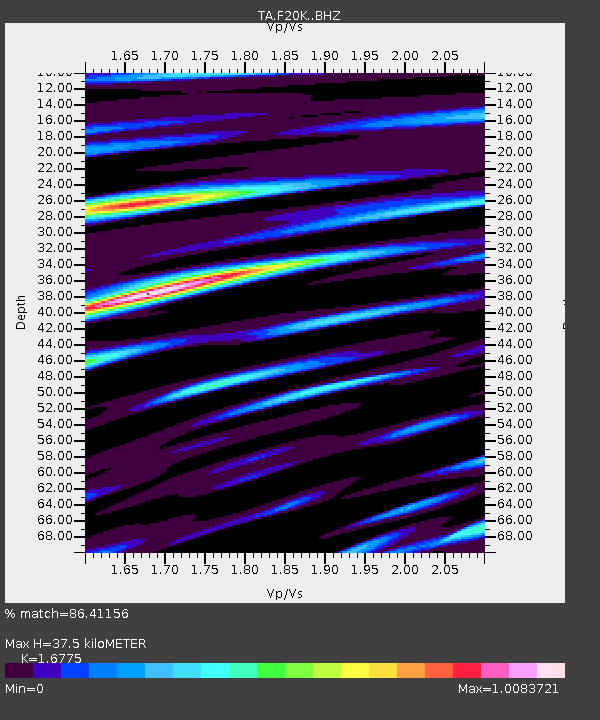
| Estimated Moho Depth: |
37.5 km |
| Estimated Crust Vp/Vs: |
1.68 |
| Assumed Crust Vp: |
6.522 km/s |
| Estimated Crust Vs: |
3.888 km/s |
| Estimated Crust Poisson's Ratio: |
0.22 |
|
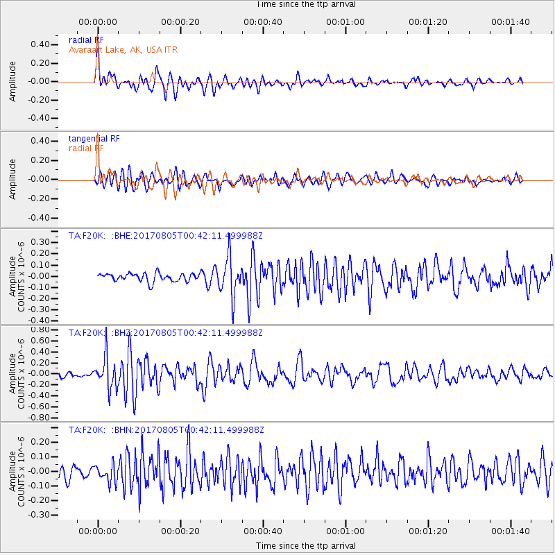
| Radial Match: |
86.41156 % |
| Radial Bump: |
400 |
| Transverse Match: |
70.192024 % |
| Transverse Bump: |
400 |
| SOD ConfigId: |
13570011 |
| Insert Time: |
2019-04-28 12:55:35.451 +0000 |
| GWidth: |
2.5 |
| Max Bumps: |
400 |
| Tol: |
0.001 |
|
Signal To Noise
| Channel | StoN | STA | LTA |
| TA:F20K: :BHZ:20170805T00:42:11.499988Z | 6.5655594 | 2.9785255E-7 | 4.536591E-8 |
| TA:F20K: :BHN:20170805T00:42:11.499988Z | 1.3023664 | 6.025247E-8 | 4.6263835E-8 |
| TA:F20K: :BHE:20170805T00:42:11.499988Z | 4.86515 | 1.7572182E-7 | 3.611848E-8 |
| Arrivals |
| Ps | 4.0 SECOND |
| PpPs | 15 SECOND |
| PsPs/PpSs | 19 SECOND |


