You are here: Home > Network List > TA - USArray Transportable Network (new EarthScope stations) Stations List
> Station G21K Allakaket, AK, USA > Earthquake Result Viewer
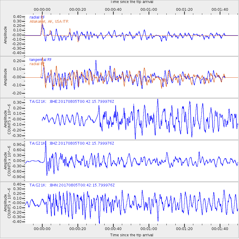
G21K Allakaket, AK, USA - Earthquake Result Viewer
*The percent match for this event was below the threshold and hence no stack was calculated.
| Earthquake location: |
Mindanao, Philippines |
| Earthquake latitude/longitude: |
6.2/125.5 |
| Earthquake time(UTC): |
2017/08/05 (217) 00:30:41 GMT |
| Earthquake Depth: |
74 km |
| Earthquake Magnitude: |
5.8 Mww |
| Earthquake Catalog/Contributor: |
NEIC PDE/us |
|
| Network: |
TA USArray Transportable Network (new EarthScope stations) |
| Station: |
G21K Allakaket, AK, USA |
| Lat/Lon: |
66.52 N/153.51 W |
| Elevation: |
446 m |
|
| Distance: |
80.8 deg |
| Az: |
23.643 deg |
| Baz: |
264.23 deg |
| Ray Param: |
$rayparam |
*The percent match for this event was below the threshold and hence was not used in the summary stack. |
|
| Radial Match: |
74.008514 % |
| Radial Bump: |
400 |
| Transverse Match: |
73.1866 % |
| Transverse Bump: |
400 |
| SOD ConfigId: |
13570011 |
| Insert Time: |
2019-04-28 12:55:43.797 +0000 |
| GWidth: |
2.5 |
| Max Bumps: |
400 |
| Tol: |
0.001 |
|
Signal To Noise
| Channel | StoN | STA | LTA |
| TA:G21K: :BHZ:20170805T00:42:15.799976Z | 7.2573285 | 3.927907E-7 | 5.412332E-8 |
| TA:G21K: :BHN:20170805T00:42:15.799976Z | 1.7480001 | 9.530882E-8 | 5.452449E-8 |
| TA:G21K: :BHE:20170805T00:42:15.799976Z | 1.8033121 | 1.07785795E-7 | 5.977102E-8 |
| Arrivals |
| Ps | |
| PpPs | |
| PsPs/PpSs | |


