You are here: Home > Network List > TA - USArray Transportable Network (new EarthScope stations) Stations List
> Station I20A Worland, WY, USA > Earthquake Result Viewer
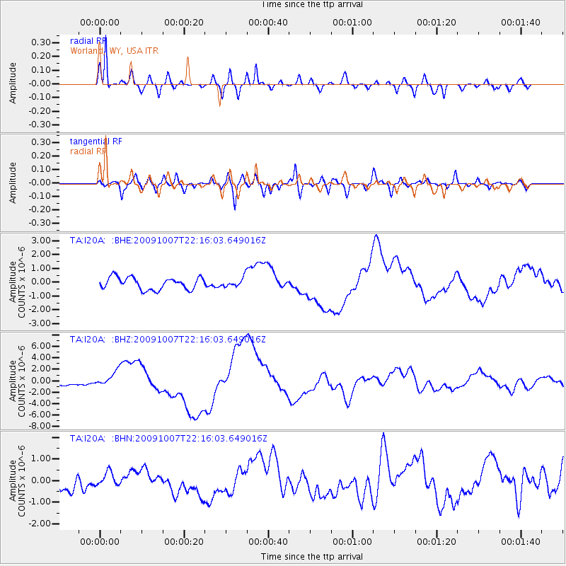
I20A Worland, WY, USA - Earthquake Result Viewer
*The percent match for this event was below the threshold and hence no stack was calculated.
| Earthquake location: |
Vanuatu Islands |
| Earthquake latitude/longitude: |
-13.0/166.5 |
| Earthquake time(UTC): |
2009/10/07 (280) 22:03:14 GMT |
| Earthquake Depth: |
45 km |
| Earthquake Magnitude: |
6.4 MB, 7.3 MS, 7.6 MW, 7.7 MW |
| Earthquake Catalog/Contributor: |
WHDF/NEIC |
|
| Network: |
TA USArray Transportable Network (new EarthScope stations) |
| Station: |
I20A Worland, WY, USA |
| Lat/Lon: |
43.95 N/108.13 W |
| Elevation: |
1342 m |
|
| Distance: |
95.6 deg |
| Az: |
46.334 deg |
| Baz: |
257.463 deg |
| Ray Param: |
$rayparam |
*The percent match for this event was below the threshold and hence was not used in the summary stack. |
|
| Radial Match: |
92.325516 % |
| Radial Bump: |
400 |
| Transverse Match: |
72.54982 % |
| Transverse Bump: |
400 |
| SOD ConfigId: |
2622 |
| Insert Time: |
2010-03-06 02:33:55.036 +0000 |
| GWidth: |
2.5 |
| Max Bumps: |
400 |
| Tol: |
0.001 |
|
Signal To Noise
| Channel | StoN | STA | LTA |
| TA:I20A: :BHZ:20091007T22:16:03.649016Z | 4.7595286 | 1.4272683E-6 | 2.9987598E-7 |
| TA:I20A: :BHN:20091007T22:16:03.649016Z | 0.987373 | 3.492521E-7 | 3.5371852E-7 |
| TA:I20A: :BHE:20091007T22:16:03.649016Z | 0.83318144 | 3.6592775E-7 | 4.3919337E-7 |
| Arrivals |
| Ps | |
| PpPs | |
| PsPs/PpSs | |


