You are here: Home > Network List > TA - USArray Transportable Network (new EarthScope stations) Stations List
> Station I20A Worland, WY, USA > Earthquake Result Viewer
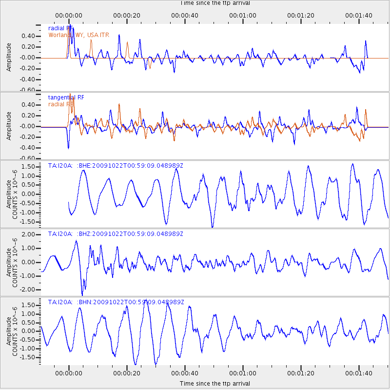
I20A Worland, WY, USA - Earthquake Result Viewer
*The percent match for this event was below the threshold and hence no stack was calculated.
| Earthquake location: |
South Of Panama |
| Earthquake latitude/longitude: |
6.7/-82.6 |
| Earthquake time(UTC): |
2009/10/22 (295) 00:51:39 GMT |
| Earthquake Depth: |
18 km |
| Earthquake Magnitude: |
5.5 MB, 5.4 MS, 5.9 MW, 5.9 MW |
| Earthquake Catalog/Contributor: |
WHDF/NEIC |
|
| Network: |
TA USArray Transportable Network (new EarthScope stations) |
| Station: |
I20A Worland, WY, USA |
| Lat/Lon: |
43.95 N/108.13 W |
| Elevation: |
1342 m |
|
| Distance: |
43.3 deg |
| Az: |
332.988 deg |
| Baz: |
141.352 deg |
| Ray Param: |
$rayparam |
*The percent match for this event was below the threshold and hence was not used in the summary stack. |
|
| Radial Match: |
65.663 % |
| Radial Bump: |
334 |
| Transverse Match: |
63.83735 % |
| Transverse Bump: |
363 |
| SOD ConfigId: |
2622 |
| Insert Time: |
2010-03-06 02:33:57.465 +0000 |
| GWidth: |
2.5 |
| Max Bumps: |
400 |
| Tol: |
0.001 |
|
Signal To Noise
| Channel | StoN | STA | LTA |
| TA:I20A: :BHZ:20091022T00:59:09.048989Z | 2.6962488 | 1.0484312E-6 | 3.8884806E-7 |
| TA:I20A: :BHN:20091022T00:59:09.048989Z | 1.4573486 | 9.144381E-7 | 6.27467E-7 |
| TA:I20A: :BHE:20091022T00:59:09.048989Z | 1.3660358 | 9.1578806E-7 | 6.7039826E-7 |
| Arrivals |
| Ps | |
| PpPs | |
| PsPs/PpSs | |


