You are here: Home > Network List > TA - USArray Transportable Network (new EarthScope stations) Stations List
> Station I20A Worland, WY, USA > Earthquake Result Viewer
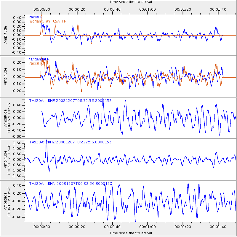
I20A Worland, WY, USA - Earthquake Result Viewer
*The percent match for this event was below the threshold and hence no stack was calculated.
| Earthquake location: |
Northern Mid-Atlantic Ridge |
| Earthquake latitude/longitude: |
13.4/-44.8 |
| Earthquake time(UTC): |
2008/12/07 (342) 06:23:09 GMT |
| Earthquake Depth: |
10 km |
| Earthquake Magnitude: |
5.6 MB, 5.3 MS, 5.7 MW |
| Earthquake Catalog/Contributor: |
WHDF/NEIC |
|
| Network: |
TA USArray Transportable Network (new EarthScope stations) |
| Station: |
I20A Worland, WY, USA |
| Lat/Lon: |
43.95 N/108.13 W |
| Elevation: |
1342 m |
|
| Distance: |
61.7 deg |
| Az: |
312.856 deg |
| Baz: |
98.936 deg |
| Ray Param: |
$rayparam |
*The percent match for this event was below the threshold and hence was not used in the summary stack. |
|
| Radial Match: |
48.96523 % |
| Radial Bump: |
400 |
| Transverse Match: |
48.89314 % |
| Transverse Bump: |
400 |
| SOD ConfigId: |
2658 |
| Insert Time: |
2010-03-06 02:34:14.881 +0000 |
| GWidth: |
2.5 |
| Max Bumps: |
400 |
| Tol: |
0.001 |
|
Signal To Noise
| Channel | StoN | STA | LTA |
| TA:I20A: :BHZ:20081207T06:32:56.800015Z | 4.387644 | 7.025059E-7 | 1.6011005E-7 |
| TA:I20A: :BHN:20081207T06:32:56.800015Z | 0.8270102 | 1.3190336E-7 | 1.5949425E-7 |
| TA:I20A: :BHE:20081207T06:32:56.800015Z | 2.0423155 | 2.7085105E-7 | 1.3261959E-7 |
| Arrivals |
| Ps | |
| PpPs | |
| PsPs/PpSs | |


