You are here: Home > Network List > TA - USArray Transportable Network (new EarthScope stations) Stations List
> Station I20A Worland, WY, USA > Earthquake Result Viewer
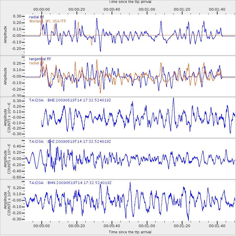
I20A Worland, WY, USA - Earthquake Result Viewer
*The percent match for this event was below the threshold and hence no stack was calculated.
| Earthquake location: |
Eastern Mediterranean Sea |
| Earthquake latitude/longitude: |
35.4/28.5 |
| Earthquake time(UTC): |
2009/06/19 (170) 14:04:59 GMT |
| Earthquake Depth: |
28 km |
| Earthquake Magnitude: |
5.6 MB, 5.6 MS, 5.8 MW, 5.8 MW |
| Earthquake Catalog/Contributor: |
WHDF/NEIC |
|
| Network: |
TA USArray Transportable Network (new EarthScope stations) |
| Station: |
I20A Worland, WY, USA |
| Lat/Lon: |
43.95 N/108.13 W |
| Elevation: |
1342 m |
|
| Distance: |
91.7 deg |
| Az: |
330.22 deg |
| Baz: |
34.199 deg |
| Ray Param: |
$rayparam |
*The percent match for this event was below the threshold and hence was not used in the summary stack. |
|
| Radial Match: |
66.85889 % |
| Radial Bump: |
400 |
| Transverse Match: |
51.72576 % |
| Transverse Bump: |
400 |
| SOD ConfigId: |
2648 |
| Insert Time: |
2010-03-06 02:34:19.603 +0000 |
| GWidth: |
2.5 |
| Max Bumps: |
400 |
| Tol: |
0.001 |
|
Signal To Noise
| Channel | StoN | STA | LTA |
| TA:I20A: :BHZ:20090619T14:17:32.524019Z | 3.249873 | 2.506696E-7 | 7.713212E-8 |
| TA:I20A: :BHN:20090619T14:17:32.524019Z | 1.0249562 | 7.225646E-8 | 7.049712E-8 |
| TA:I20A: :BHE:20090619T14:17:32.524019Z | 0.31246048 | 3.4341912E-8 | 1.0990802E-7 |
| Arrivals |
| Ps | |
| PpPs | |
| PsPs/PpSs | |


