You are here: Home > Network List > TA - USArray Transportable Network (new EarthScope stations) Stations List
> Station I20A Worland, WY, USA > Earthquake Result Viewer
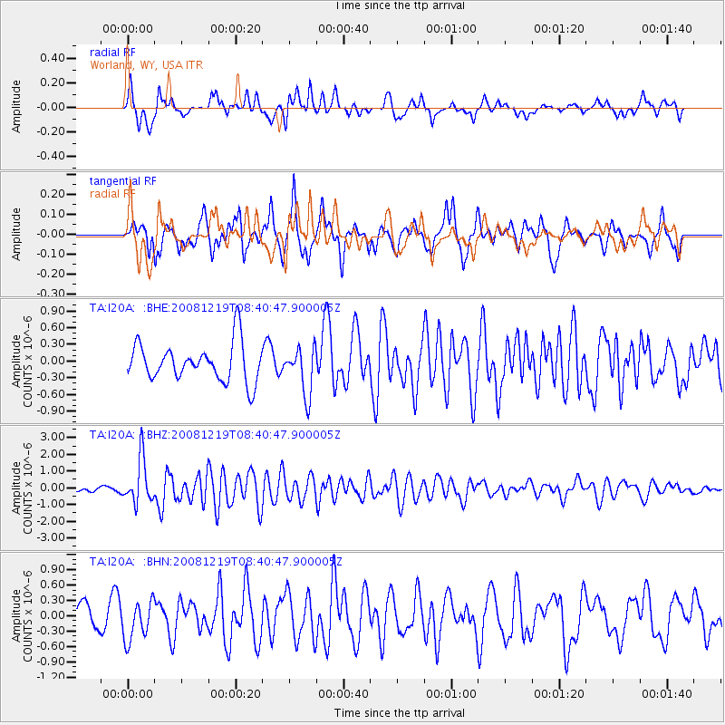
I20A Worland, WY, USA - Earthquake Result Viewer
*The percent match for this event was below the threshold and hence no stack was calculated.
| Earthquake location: |
Northern Mid-Atlantic Ridge |
| Earthquake latitude/longitude: |
47.0/-27.3 |
| Earthquake time(UTC): |
2008/12/19 (354) 08:31:51 GMT |
| Earthquake Depth: |
2.0 km |
| Earthquake Magnitude: |
5.8 MB, 5.6 MS, 5.9 MW, 5.8 MW |
| Earthquake Catalog/Contributor: |
WHDF/NEIC |
|
| Network: |
TA USArray Transportable Network (new EarthScope stations) |
| Station: |
I20A Worland, WY, USA |
| Lat/Lon: |
43.95 N/108.13 W |
| Elevation: |
1342 m |
|
| Distance: |
54.3 deg |
| Az: |
298.646 deg |
| Baz: |
56.265 deg |
| Ray Param: |
$rayparam |
*The percent match for this event was below the threshold and hence was not used in the summary stack. |
|
| Radial Match: |
69.82016 % |
| Radial Bump: |
400 |
| Transverse Match: |
74.85301 % |
| Transverse Bump: |
400 |
| SOD ConfigId: |
2658 |
| Insert Time: |
2010-03-06 02:34:23.681 +0000 |
| GWidth: |
2.5 |
| Max Bumps: |
400 |
| Tol: |
0.001 |
|
Signal To Noise
| Channel | StoN | STA | LTA |
| TA:I20A: :BHZ:20081219T08:40:47.900005Z | 7.273302 | 1.3502518E-6 | 1.8564495E-7 |
| TA:I20A: :BHN:20081219T08:40:47.900005Z | 1.6495458 | 3.8487735E-7 | 2.3332323E-7 |
| TA:I20A: :BHE:20081219T08:40:47.900005Z | 1.2539935 | 4.2741107E-7 | 3.4083993E-7 |
| Arrivals |
| Ps | |
| PpPs | |
| PsPs/PpSs | |


