You are here: Home > Network List > TA - USArray Transportable Network (new EarthScope stations) Stations List
> Station I20A Worland, WY, USA > Earthquake Result Viewer
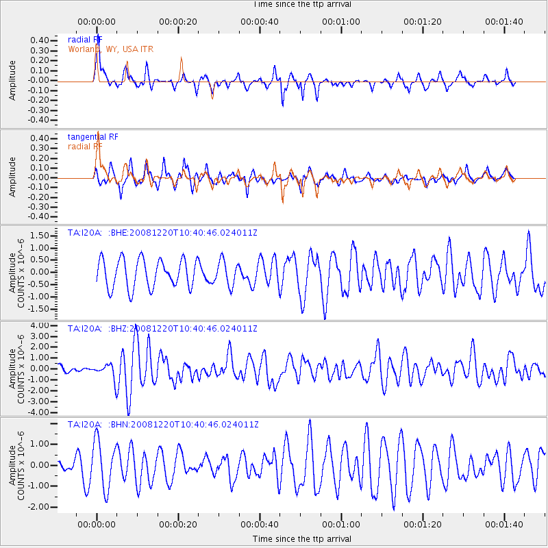
I20A Worland, WY, USA - Earthquake Result Viewer
*The percent match for this event was below the threshold and hence no stack was calculated.
| Earthquake location: |
Off East Coast Of Honshu, Japan |
| Earthquake latitude/longitude: |
36.5/142.4 |
| Earthquake time(UTC): |
2008/12/20 (355) 10:29:23 GMT |
| Earthquake Depth: |
19 km |
| Earthquake Magnitude: |
6.0 MB, 6.3 MS, 6.3 MW, 6.3 MW |
| Earthquake Catalog/Contributor: |
WHDF/NEIC |
|
| Network: |
TA USArray Transportable Network (new EarthScope stations) |
| Station: |
I20A Worland, WY, USA |
| Lat/Lon: |
43.95 N/108.13 W |
| Elevation: |
1342 m |
|
| Distance: |
77.5 deg |
| Az: |
44.234 deg |
| Baz: |
308.939 deg |
| Ray Param: |
$rayparam |
*The percent match for this event was below the threshold and hence was not used in the summary stack. |
|
| Radial Match: |
67.68683 % |
| Radial Bump: |
296 |
| Transverse Match: |
57.529396 % |
| Transverse Bump: |
398 |
| SOD ConfigId: |
2658 |
| Insert Time: |
2010-03-06 02:34:25.562 +0000 |
| GWidth: |
2.5 |
| Max Bumps: |
400 |
| Tol: |
0.001 |
|
Signal To Noise
| Channel | StoN | STA | LTA |
| TA:I20A: :BHZ:20081220T10:40:46.024011Z | 2.1056025 | 7.074024E-7 | 3.35962E-7 |
| TA:I20A: :BHN:20081220T10:40:46.024011Z | 1.8987263 | 1.1658872E-6 | 6.140364E-7 |
| TA:I20A: :BHE:20081220T10:40:46.024011Z | 0.8709572 | 5.071465E-7 | 5.8228636E-7 |
| Arrivals |
| Ps | |
| PpPs | |
| PsPs/PpSs | |


