You are here: Home > Network List > TA - USArray Transportable Network (new EarthScope stations) Stations List
> Station I20A Worland, WY, USA > Earthquake Result Viewer
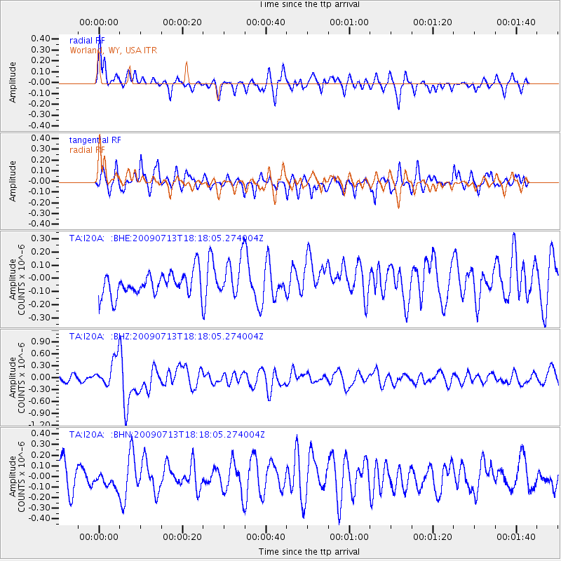
I20A Worland, WY, USA - Earthquake Result Viewer
*The percent match for this event was below the threshold and hence no stack was calculated.
| Earthquake location: |
Taiwan Region |
| Earthquake latitude/longitude: |
24.1/122.2 |
| Earthquake time(UTC): |
2009/07/13 (194) 18:05:01 GMT |
| Earthquake Depth: |
17 km |
| Earthquake Magnitude: |
6.1 MB, 6.3 MS, 6.3 MW, 6.2 MW |
| Earthquake Catalog/Contributor: |
WHDF/NEIC |
|
| Network: |
TA USArray Transportable Network (new EarthScope stations) |
| Station: |
I20A Worland, WY, USA |
| Lat/Lon: |
43.95 N/108.13 W |
| Elevation: |
1342 m |
|
| Distance: |
98.1 deg |
| Az: |
34.165 deg |
| Baz: |
314.702 deg |
| Ray Param: |
$rayparam |
*The percent match for this event was below the threshold and hence was not used in the summary stack. |
|
| Radial Match: |
60.55318 % |
| Radial Bump: |
400 |
| Transverse Match: |
68.76272 % |
| Transverse Bump: |
364 |
| SOD ConfigId: |
2648 |
| Insert Time: |
2010-03-06 02:34:30.233 +0000 |
| GWidth: |
2.5 |
| Max Bumps: |
400 |
| Tol: |
0.001 |
|
Signal To Noise
| Channel | StoN | STA | LTA |
| TA:I20A: :BHZ:20090713T18:18:05.274004Z | 3.3237784 | 3.7669068E-7 | 1.1333207E-7 |
| TA:I20A: :BHN:20090713T18:18:05.274004Z | 0.5546003 | 7.9283545E-8 | 1.429562E-7 |
| TA:I20A: :BHE:20090713T18:18:05.274004Z | 1.7592193 | 1.5464303E-7 | 8.7904354E-8 |
| Arrivals |
| Ps | |
| PpPs | |
| PsPs/PpSs | |


