You are here: Home > Network List > TA - USArray Transportable Network (new EarthScope stations) Stations List
> Station F26K Sheenjek River, AK, USA > Earthquake Result Viewer
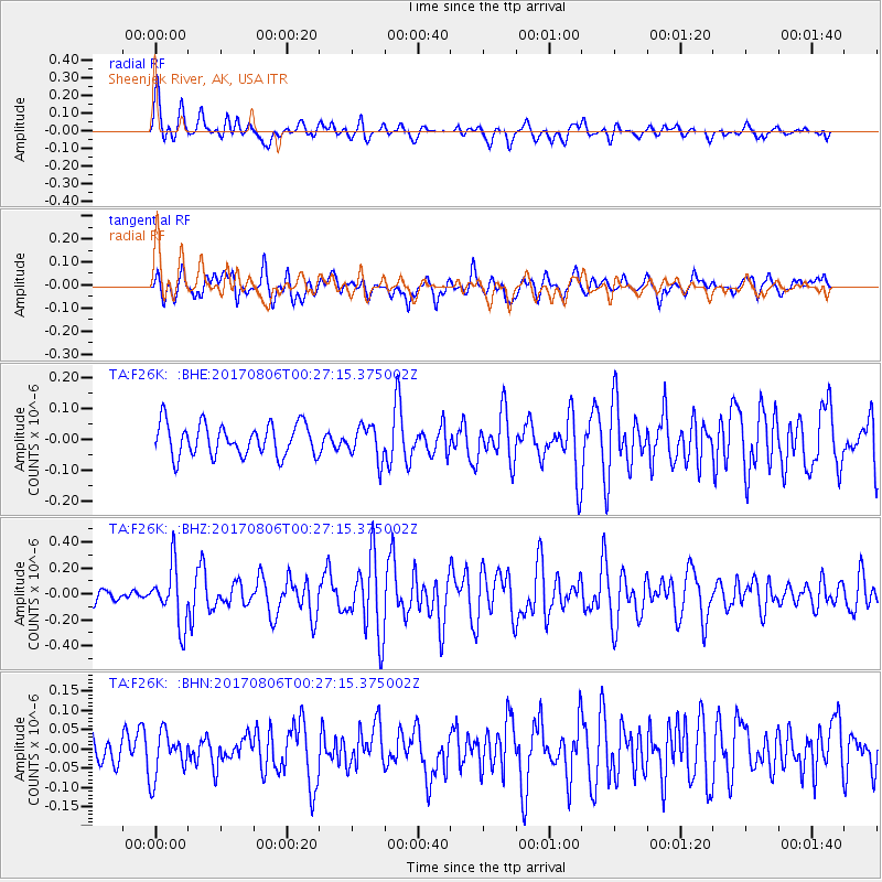
F26K Sheenjek River, AK, USA - Earthquake Result Viewer
*The percent match for this event was below the threshold and hence no stack was calculated.
| Earthquake location: |
Solomon Islands |
| Earthquake latitude/longitude: |
-10.3/161.5 |
| Earthquake time(UTC): |
2017/08/06 (218) 00:15:10 GMT |
| Earthquake Depth: |
73 km |
| Earthquake Magnitude: |
5.7 Mww |
| Earthquake Catalog/Contributor: |
NEIC PDE/us |
|
| Network: |
TA USArray Transportable Network (new EarthScope stations) |
| Station: |
F26K Sheenjek River, AK, USA |
| Lat/Lon: |
67.69 N/144.15 W |
| Elevation: |
683 m |
|
| Distance: |
86.8 deg |
| Az: |
18.105 deg |
| Baz: |
233.248 deg |
| Ray Param: |
$rayparam |
*The percent match for this event was below the threshold and hence was not used in the summary stack. |
|
| Radial Match: |
68.08521 % |
| Radial Bump: |
400 |
| Transverse Match: |
70.31496 % |
| Transverse Bump: |
400 |
| SOD ConfigId: |
13570011 |
| Insert Time: |
2019-04-28 13:01:54.075 +0000 |
| GWidth: |
2.5 |
| Max Bumps: |
400 |
| Tol: |
0.001 |
|
Signal To Noise
| Channel | StoN | STA | LTA |
| TA:F26K: :BHZ:20170806T00:27:15.375002Z | 3.1928577 | 2.2304137E-7 | 6.985635E-8 |
| TA:F26K: :BHN:20170806T00:27:15.375002Z | 1.320342 | 5.928365E-8 | 4.4900226E-8 |
| TA:F26K: :BHE:20170806T00:27:15.375002Z | 1.0462185 | 5.4482776E-8 | 5.2075908E-8 |
| Arrivals |
| Ps | |
| PpPs | |
| PsPs/PpSs | |


