You are here: Home > Network List > TA - USArray Transportable Network (new EarthScope stations) Stations List
> Station H25A Fruitdale, SD, USA > Earthquake Result Viewer
H25A Fruitdale, SD, USA - Earthquake Result Viewer
| Earthquake location: |
Peru-Bolivia Border Region |
| Earthquake latitude/longitude: |
-15.6/-69.3 |
| Earthquake time(UTC): |
2009/09/30 (273) 19:03:17 GMT |
| Earthquake Depth: |
255 km |
| Earthquake Magnitude: |
5.9 MB, 5.8 MW |
| Earthquake Catalog/Contributor: |
WHDF/NEIC |
|
| Network: |
TA USArray Transportable Network (new EarthScope stations) |
| Station: |
H25A Fruitdale, SD, USA |
| Lat/Lon: |
44.62 N/103.60 W |
| Elevation: |
942 m |
|
| Distance: |
67.5 deg |
| Az: |
334.182 deg |
| Baz: |
143.997 deg |
| Ray Param: |
0.056131374 |
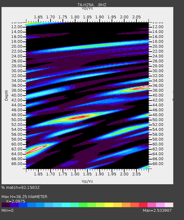
| Estimated Moho Depth: |
36.25 km |
| Estimated Crust Vp/Vs: |
2.10 |
| Assumed Crust Vp: |
6.242 km/s |
| Estimated Crust Vs: |
2.976 km/s |
| Estimated Crust Poisson's Ratio: |
0.35 |
|
| Radial Match: |
82.15832 % |
| Radial Bump: |
400 |
| Transverse Match: |
72.8386 % |
| Transverse Bump: |
400 |
| SOD ConfigId: |
2622 |
| Insert Time: |
2010-03-06 02:34:51.778 +0000 |
| GWidth: |
2.5 |
| Max Bumps: |
400 |
| Tol: |
0.001 |
|
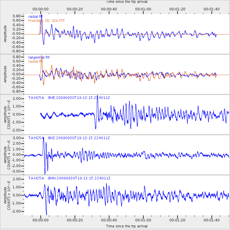
Signal To Noise
| Channel | StoN | STA | LTA |
| TA:H25A: :BHZ:20090930T19:13:15.224011Z | 13.539531 | 1.607341E-6 | 1.18714674E-7 |
| TA:H25A: :BHN:20090930T19:13:15.224011Z | 5.0060883 | 8.6572095E-7 | 1.7293362E-7 |
| TA:H25A: :BHE:20090930T19:13:15.224011Z | 5.6123157 | 9.627524E-7 | 1.7154282E-7 |
| Arrivals |
| Ps | 6.6 SECOND |
| PpPs | 17 SECOND |
| PsPs/PpSs | 24 SECOND |


