You are here: Home > Network List > TA - USArray Transportable Network (new EarthScope stations) Stations List
> Station H31M Peel River, Yukon, CAN > Earthquake Result Viewer
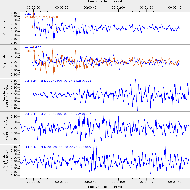
H31M Peel River, Yukon, CAN - Earthquake Result Viewer
*The percent match for this event was below the threshold and hence no stack was calculated.
| Earthquake location: |
Solomon Islands |
| Earthquake latitude/longitude: |
-10.3/161.5 |
| Earthquake time(UTC): |
2017/08/06 (218) 00:15:10 GMT |
| Earthquake Depth: |
73 km |
| Earthquake Magnitude: |
5.7 Mww |
| Earthquake Catalog/Contributor: |
NEIC PDE/us |
|
| Network: |
TA USArray Transportable Network (new EarthScope stations) |
| Station: |
H31M Peel River, Yukon, CAN |
| Lat/Lon: |
65.81 N/134.34 W |
| Elevation: |
642 m |
|
| Distance: |
89.1 deg |
| Az: |
21.779 deg |
| Baz: |
242.38 deg |
| Ray Param: |
$rayparam |
*The percent match for this event was below the threshold and hence was not used in the summary stack. |
|
| Radial Match: |
75.25347 % |
| Radial Bump: |
400 |
| Transverse Match: |
62.427555 % |
| Transverse Bump: |
400 |
| SOD ConfigId: |
13570011 |
| Insert Time: |
2019-04-28 13:02:10.560 +0000 |
| GWidth: |
2.5 |
| Max Bumps: |
400 |
| Tol: |
0.001 |
|
Signal To Noise
| Channel | StoN | STA | LTA |
| TA:H31M: :BHZ:20170806T00:27:26.250002Z | 3.594872 | 1.7566254E-7 | 4.8864756E-8 |
| TA:H31M: :BHN:20170806T00:27:26.250002Z | 1.7879751 | 8.439234E-8 | 4.7199954E-8 |
| TA:H31M: :BHE:20170806T00:27:26.250002Z | 2.7149067 | 1.1851034E-7 | 4.3651717E-8 |
| Arrivals |
| Ps | |
| PpPs | |
| PsPs/PpSs | |


