You are here: Home > Network List > TA - USArray Transportable Network (new EarthScope stations) Stations List
> Station H25A Fruitdale, SD, USA > Earthquake Result Viewer
H25A Fruitdale, SD, USA - Earthquake Result Viewer

| Earthquake location: |
Ryukyu Islands, Japan |
| Earthquake latitude/longitude: |
29.2/129.8 |
| Earthquake time(UTC): |
2009/10/30 (303) 07:03:39 GMT |
| Earthquake Depth: |
34 km |
| Earthquake Magnitude: |
6.3 MB, 6.8 MS, 6.8 MW, 6.8 MW |
| Earthquake Catalog/Contributor: |
WHDF/NEIC |
|
| Network: |
TA USArray Transportable Network (new EarthScope stations) |
| Station: |
H25A Fruitdale, SD, USA |
| Lat/Lon: |
44.62 N/103.60 W |
| Elevation: |
942 m |
|
| Distance: |
91.9 deg |
| Az: |
34.992 deg |
| Baz: |
315.414 deg |
| Ray Param: |
0.041537404 |
| Estimated Moho Depth: |
18.75 km |
| Estimated Crust Vp/Vs: |
2.10 |
| Assumed Crust Vp: |
6.242 km/s |
| Estimated Crust Vs: |
2.976 km/s |
| Estimated Crust Poisson's Ratio: |
0.35 |
|
| Radial Match: |
89.68738 % |
| Radial Bump: |
399 |
| Transverse Match: |
89.38668 % |
| Transverse Bump: |
400 |
| SOD ConfigId: |
2622 |
| Insert Time: |
2010-03-06 02:34:53.592 +0000 |
| GWidth: |
2.5 |
| Max Bumps: |
400 |
| Tol: |
0.001 |
|
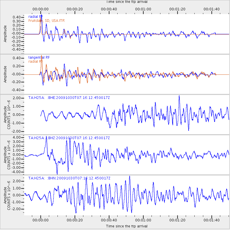
Signal To Noise
| Channel | StoN | STA | LTA |
| TA:H25A: :BHZ:20091030T07:16:12.450017Z | 10.773136 | 1.5996658E-6 | 1.4848654E-7 |
| TA:H25A: :BHN:20091030T07:16:12.450017Z | 1.9744831 | 4.0454657E-7 | 2.0488733E-7 |
| TA:H25A: :BHE:20091030T07:16:12.450017Z | 2.012016 | 5.8782325E-7 | 2.9215636E-7 |
| Arrivals |
| Ps | 3.4 SECOND |
| PpPs | 9.2 SECOND |
| PsPs/PpSs | 13 SECOND |


