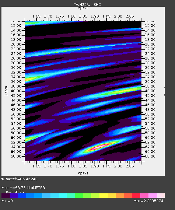
H25A Fruitdale, SD, USA - Earthquake Result Viewer
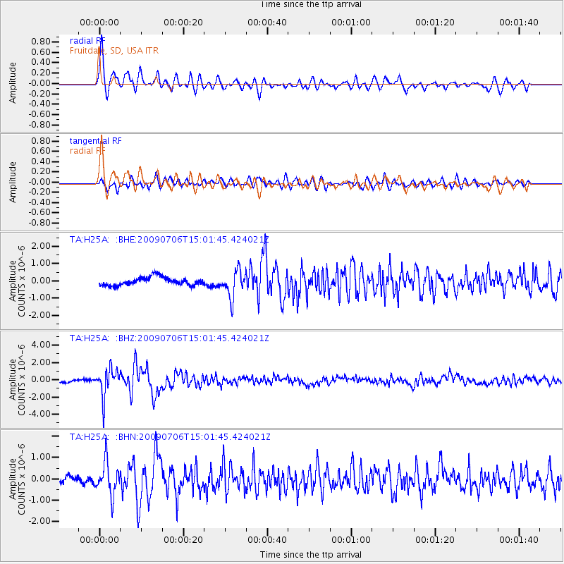
Earthquake location: Rat Islands, Aleutian Islands
Earthquake latitude/longitude: 50.4/177.0
Earthquake time(UTC): 2009/07/06 (187) 14:53:12 GMT
Earthquake Depth: 22 km
Earthquake Magnitude: 6.0 MB, 5.8 MS, 6.1 MW, 6.0 MW
Earthquake Catalog/Contributor: WHDF/NEIC
Network: TA USArray Transportable Network (new EarthScope stations)
Station: H25A Fruitdale, SD, USA
Lat/Lon: 44.62 N/103.60 W
Elevation: 942 m
Distance: 51.5 deg
Az: 63.711 deg
Baz: 306.594 deg
Ray Param: 0.0673241
Estimated Moho Depth: 63.75 km
Estimated Crust Vp/Vs: 1.92
Assumed Crust Vp: 6.242 km/s
Estimated Crust Vs: 3.255 km/s
Estimated Crust Poisson's Ratio: 0.31
Radial Match: 85.46248 %
Radial Bump: 400
Transverse Match: 78.927475 %
Transverse Bump: 400
SOD ConfigId: 2648
Insert Time: 2010-03-06 02:34:54.409 +0000
GWidth: 2.5
Max Bumps: 400
Tol: 0.001

Signal To Noise

ChannelStoNSTALTA
TA:H25A: :BHZ:20090706T15:01:45.424021Z9.4323611.655701E-61.7553411E-7
TA:H25A: :BHN:20090706T15:01:45.424021Z4.8266767.809898E-71.6180698E-7
TA:H25A: :BHE:20090706T15:01:45.424021Z3.42832838.02603E-72.3410912E-7
Arrivals
Ps9.8 SECOND
PpPs28 SECOND
PsPs/PpSs38 SECOND