You are here: Home > Network List > TA - USArray Transportable Network (new EarthScope stations) Stations List
> Station I30M Mount Dempster, Yukon, CAN > Earthquake Result Viewer
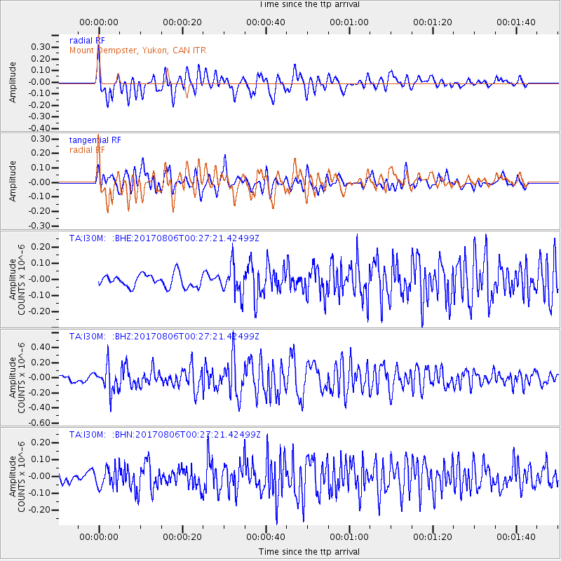
I30M Mount Dempster, Yukon, CAN - Earthquake Result Viewer
*The percent match for this event was below the threshold and hence no stack was calculated.
| Earthquake location: |
Solomon Islands |
| Earthquake latitude/longitude: |
-10.3/161.5 |
| Earthquake time(UTC): |
2017/08/06 (218) 00:15:10 GMT |
| Earthquake Depth: |
73 km |
| Earthquake Magnitude: |
5.7 Mww |
| Earthquake Catalog/Contributor: |
NEIC PDE/us |
|
| Network: |
TA USArray Transportable Network (new EarthScope stations) |
| Station: |
I30M Mount Dempster, Yukon, CAN |
| Lat/Lon: |
65.22 N/136.38 W |
| Elevation: |
1399 m |
|
| Distance: |
88.1 deg |
| Az: |
21.888 deg |
| Baz: |
240.534 deg |
| Ray Param: |
$rayparam |
*The percent match for this event was below the threshold and hence was not used in the summary stack. |
|
| Radial Match: |
74.79251 % |
| Radial Bump: |
400 |
| Transverse Match: |
71.75939 % |
| Transverse Bump: |
400 |
| SOD ConfigId: |
13570011 |
| Insert Time: |
2019-04-28 13:02:17.321 +0000 |
| GWidth: |
2.5 |
| Max Bumps: |
400 |
| Tol: |
0.001 |
|
Signal To Noise
| Channel | StoN | STA | LTA |
| TA:I30M: :BHZ:20170806T00:27:21.42499Z | 4.0873766 | 1.6915118E-7 | 4.1383803E-8 |
| TA:I30M: :BHN:20170806T00:27:21.42499Z | 1.5597689 | 5.778396E-8 | 3.7046487E-8 |
| TA:I30M: :BHE:20170806T00:27:21.42499Z | 2.2680728 | 8.9309005E-8 | 3.9376605E-8 |
| Arrivals |
| Ps | |
| PpPs | |
| PsPs/PpSs | |


