You are here: Home > Network List > TA - USArray Transportable Network (new EarthScope stations) Stations List
> Station M19K Big River Lodge, Big River, AK, USA > Earthquake Result Viewer
M19K Big River Lodge, Big River, AK, USA - Earthquake Result Viewer
| Earthquake location: |
Solomon Islands |
| Earthquake latitude/longitude: |
-10.3/161.5 |
| Earthquake time(UTC): |
2017/08/06 (218) 00:15:10 GMT |
| Earthquake Depth: |
73 km |
| Earthquake Magnitude: |
5.7 Mww |
| Earthquake Catalog/Contributor: |
NEIC PDE/us |
|
| Network: |
TA USArray Transportable Network (new EarthScope stations) |
| Station: |
M19K Big River Lodge, Big River, AK, USA |
| Lat/Lon: |
61.90 N/154.39 W |
| Elevation: |
521 m |
|
| Distance: |
79.7 deg |
| Az: |
19.574 deg |
| Baz: |
224.145 deg |
| Ray Param: |
0.048617996 |
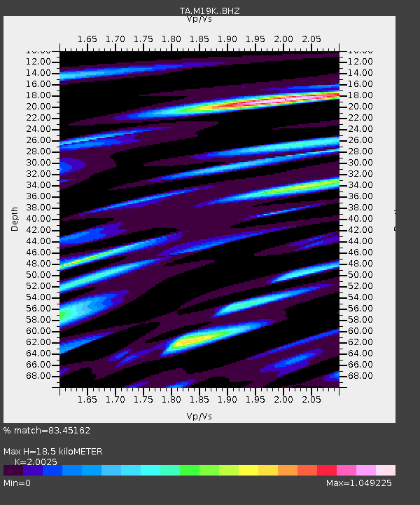
| Estimated Moho Depth: |
18.5 km |
| Estimated Crust Vp/Vs: |
2.00 |
| Assumed Crust Vp: |
6.566 km/s |
| Estimated Crust Vs: |
3.279 km/s |
| Estimated Crust Poisson's Ratio: |
0.33 |
|
| Radial Match: |
83.45162 % |
| Radial Bump: |
400 |
| Transverse Match: |
67.92143 % |
| Transverse Bump: |
400 |
| SOD ConfigId: |
13570011 |
| Insert Time: |
2019-04-28 13:02:39.378 +0000 |
| GWidth: |
2.5 |
| Max Bumps: |
400 |
| Tol: |
0.001 |
|

Signal To Noise
| Channel | StoN | STA | LTA |
| TA:M19K: :BHZ:20170806T00:26:38.92499Z | 6.751084 | 6.3849194E-7 | 9.4576215E-8 |
| TA:M19K: :BHN:20170806T00:26:38.92499Z | 2.3238688 | 2.1503504E-7 | 9.253321E-8 |
| TA:M19K: :BHE:20170806T00:26:38.92499Z | 2.7127547 | 2.8933735E-7 | 1.06658135E-7 |
| Arrivals |
| Ps | 2.9 SECOND |
| PpPs | 8.2 SECOND |
| PsPs/PpSs | 11 SECOND |


